
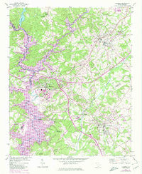
~ Clemson SC topo map, 1:24000 scale, 7.5 X 7.5 Minute, Historical, 1951, updated 1980
Clemson, South Carolina, USGS topographic map dated 1951.
Includes geographic coordinates (latitude and longitude). This topographic map is suitable for hiking, camping, and exploring, or framing it as a wall map.
Printed on-demand using high resolution imagery, on heavy weight and acid free paper, or alternatively on a variety of synthetic materials.
Topos available on paper, Waterproof, Poly, or Tyvek. Usually shipping rolled, unless combined with other folded maps in one order.
- Product Number: USGS-5386916
- Free digital map download (high-resolution, GeoPDF): Clemson, South Carolina (file size: 15 MB)
- Map Size: please refer to the dimensions of the GeoPDF map above
- Weight (paper map): ca. 55 grams
- Map Type: POD USGS Topographic Map
- Map Series: HTMC
- Map Verison: Historical
- Cell ID: 9110
- Scan ID: 260873
- Imprint Year: 1980
- Woodland Tint: Yes
- Photo Revision Year: 1980
- Aerial Photo Year: 1977
- Edit Year: 1980
- Field Check Year: 1951
- Datum: NAD27
- Map Projection: Polyconic
- Map published by United States Geological Survey
- Map Language: English
- Scanner Resolution: 600 dpi
- Map Cell Name: Clemson
- Grid size: 7.5 X 7.5 Minute
- Date on map: 1951
- Map Scale: 1:24000
- Geographical region: South Carolina, United States
Neighboring Maps:
All neighboring USGS topo maps are available for sale online at a variety of scales.
Spatial coverage:
Topo map Clemson, South Carolina, covers the geographical area associated the following places:
- Calhoun Courts - Adams Crossing - Forest Hills - Camelot - Cadillac Heights - Berkeley Forest - Dellwood - Meadow Brook - Monaco Estates - Highland Estates - Calhoun - Mountaindale - Sunny Acres - Clemson - Clemson Heights - Kelcar Acres - Mountain Estates - Woodland Heights - Pendleton - Heatherwood - Pendleton Gardens - Lakeview Estates - Skyview - Brookwood - Brookwood - Woodhaven - Meadow Rose - Stone Haven - Ashley Estates - Eastbriar - Clemson Gardens - Dogwood Heights - Ensenaka (historical) - Morningside Heights - Central - Isaqueena Village - Carolina Hills - Douthit Hills - Cherrys Crossing - Bay Shores - Briarwood - Warley Woods
- Map Area ID: AREA34.7534.625-82.875-82.75
- Northwest corner Lat/Long code: USGSNW34.75-82.875
- Northeast corner Lat/Long code: USGSNE34.75-82.75
- Southwest corner Lat/Long code: USGSSW34.625-82.875
- Southeast corner Lat/Long code: USGSSE34.625-82.75
- Northern map edge Latitude: 34.75
- Southern map edge Latitude: 34.625
- Western map edge Longitude: -82.875
- Eastern map edge Longitude: -82.75


