
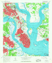
~ Charleston SC topo map, 1:24000 scale, 7.5 X 7.5 Minute, Historical, 1958, updated 1968
Charleston, South Carolina, USGS topographic map dated 1958.
Includes geographic coordinates (latitude and longitude). This topographic map is suitable for hiking, camping, and exploring, or framing it as a wall map.
Printed on-demand using high resolution imagery, on heavy weight and acid free paper, or alternatively on a variety of synthetic materials.
Topos available on paper, Waterproof, Poly, or Tyvek. Usually shipping rolled, unless combined with other folded maps in one order.
- Product Number: USGS-5386878
- Free digital map download (high-resolution, GeoPDF): Charleston, South Carolina (file size: 11 MB)
- Map Size: please refer to the dimensions of the GeoPDF map above
- Weight (paper map): ca. 55 grams
- Map Type: POD USGS Topographic Map
- Map Series: HTMC
- Map Verison: Historical
- Cell ID: 8204
- Scan ID: 260852
- Imprint Year: 1968
- Woodland Tint: Yes
- Aerial Photo Year: 1957
- Survey Year: 1958
- Datum: NAD27
- Map Projection: Polyconic
- Map published by United States Geological Survey
- Map Language: English
- Scanner Resolution: 600 dpi
- Map Cell Name: Charleston
- Grid size: 7.5 X 7.5 Minute
- Date on map: 1958
- Map Scale: 1:24000
- Geographical region: South Carolina, United States
Neighboring Maps:
All neighboring USGS topo maps are available for sale online at a variety of scales.
Spatial coverage:
Topo map Charleston, South Carolina, covers the geographical area associated the following places:
- Millwood - Harbor View - Riverland Terrace - Cherokee Place - Dogwood Park - Grove Creek Village - Bayview Acres - Cooper Estates - Scanlonville - Country Club Estates - Chicora Place - Garden Hill - Tillman Homes - Northbridge - Waylyn - Maryville - Remleys (historical) - Daniel Jenkins Homes - Dorchester - Laurel Park - Ashley Junction - George S Legare Homes - Charleston - Marlborough - Wespanee - Hillside - Charleston Heights - Green Acres - Wappo Heights - Sandhurst - Gadsden Green Homes - Charlestowne Estates - The Crescent - Ashleyville - I'On - Windsor Place - Parkwood Estates - North Charleston - South Windermire - Union Heights - Saint Andrews - Oak Forest - Myers - Parkshire - Remleys Point - Woodlawn - Charles Towne Village - Byrnes Downs - Whipper-Barnoy - The Groves - Old Town - Moreland - Chesterfield - Avondale - Ashley Shores - Hibernian Heights - Hobcaw Point - Murray Landing - Rosemont - Ashley Forest - Wragg Borough Homes - Anson Borough Homes
- Map Area ID: AREA32.87532.75-80-79.875
- Northwest corner Lat/Long code: USGSNW32.875-80
- Northeast corner Lat/Long code: USGSNE32.875-79.875
- Southwest corner Lat/Long code: USGSSW32.75-80
- Southeast corner Lat/Long code: USGSSE32.75-79.875
- Northern map edge Latitude: 32.875
- Southern map edge Latitude: 32.75
- Western map edge Longitude: -80
- Eastern map edge Longitude: -79.875


