
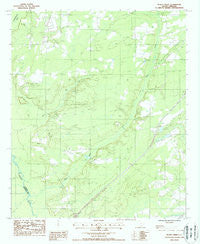
~ Black Creek SC topo map, 1:24000 scale, 7.5 X 7.5 Minute, Historical, 1988, updated 1988
Black Creek, South Carolina, USGS topographic map dated 1988.
Includes geographic coordinates (latitude and longitude). This topographic map is suitable for hiking, camping, and exploring, or framing it as a wall map.
Printed on-demand using high resolution imagery, on heavy weight and acid free paper, or alternatively on a variety of synthetic materials.
Topos available on paper, Waterproof, Poly, or Tyvek. Usually shipping rolled, unless combined with other folded maps in one order.
- Product Number: USGS-5386704
- Free digital map download (high-resolution, GeoPDF): Black Creek, South Carolina (file size: 11 MB)
- Map Size: please refer to the dimensions of the GeoPDF map above
- Weight (paper map): ca. 55 grams
- Map Type: POD USGS Topographic Map
- Map Series: HTMC
- Map Verison: Historical
- Cell ID: 4103
- Scan ID: 260759
- Imprint Year: 1988
- Woodland Tint: Yes
- Aerial Photo Year: 1980
- Edit Year: 1988
- Field Check Year: 1983
- Datum: NAD27
- Map Projection: Universal Transverse Mercator
- Provisional map: Yes
- Map published by United States Geological Survey
- Map Language: English
- Scanner Resolution: 600 dpi
- Map Cell Name: Black Creek
- Grid size: 7.5 X 7.5 Minute
- Date on map: 1988
- Map Scale: 1:24000
- Geographical region: South Carolina, United States
Neighboring Maps:
All neighboring USGS topo maps are available for sale online at a variety of scales.
Spatial coverage:
Topo map Black Creek, South Carolina, covers the geographical area associated the following places:
- Colleton County Fire - Rescue Cane Branch - Shiloh Church - Crosbys Pond - Heyward School (historical) - New Hope School - Cane Branch School (historical) - Crosbys Pond Dam D-2546 - Bull Creek - Polly Bottom School - Big Survey Lake - Cane Branch Lookout Tower - Fire Hill School - Caney Branch School - Colleton County Fire - Rescue Hendersonville - Shiloh Cemetery - Hendersonville Division - Big Survey Lake Dam D-2547 - Big Gate School (historical) - Newville School - Sandy Run - Bertha School (historical) - Marys Church - Black Creek Church - Cavern Branch School - Heyward Church - Black Creek - Interchange 42
- Map Area ID: AREA32.87532.75-80.875-80.75
- Northwest corner Lat/Long code: USGSNW32.875-80.875
- Northeast corner Lat/Long code: USGSNE32.875-80.75
- Southwest corner Lat/Long code: USGSSW32.75-80.875
- Southeast corner Lat/Long code: USGSSE32.75-80.75
- Northern map edge Latitude: 32.875
- Southern map edge Latitude: 32.75
- Western map edge Longitude: -80.875
- Eastern map edge Longitude: -80.75


