
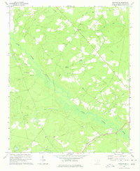
~ Bethune NW SC topo map, 1:24000 scale, 7.5 X 7.5 Minute, Historical, 1970, updated 1975
Bethune NW, South Carolina, USGS topographic map dated 1970.
Includes geographic coordinates (latitude and longitude). This topographic map is suitable for hiking, camping, and exploring, or framing it as a wall map.
Printed on-demand using high resolution imagery, on heavy weight and acid free paper, or alternatively on a variety of synthetic materials.
Topos available on paper, Waterproof, Poly, or Tyvek. Usually shipping rolled, unless combined with other folded maps in one order.
- Product Number: USGS-5386690
- Free digital map download (high-resolution, GeoPDF): Bethune NW, South Carolina (file size: 8 MB)
- Map Size: please refer to the dimensions of the GeoPDF map above
- Weight (paper map): ca. 55 grams
- Map Type: POD USGS Topographic Map
- Map Series: HTMC
- Map Verison: Historical
- Cell ID: 3553
- Scan ID: 260752
- Imprint Year: 1975
- Woodland Tint: Yes
- Aerial Photo Year: 1966
- Field Check Year: 1970
- Datum: Unstated
- Map Projection: Lambert Conformal Conic
- Map published by United States Geological Survey
- Map Language: English
- Scanner Resolution: 600 dpi
- Map Cell Name: Bethune NW
- Grid size: 7.5 X 7.5 Minute
- Date on map: 1970
- Map Scale: 1:24000
- Geographical region: South Carolina, United States
Neighboring Maps:
All neighboring USGS topo maps are available for sale online at a variety of scales.
Spatial coverage:
Topo map Bethune NW, South Carolina, covers the geographical area associated the following places:
- McGougans Bridge - Shamrock Church - Cassatt Lookout Tower - Pleasant Grove School (historical) - Scotch Cemetery - Kershaw County Fire Department Gates Ford - South Carolina Noname 28011 D-2514 Dam - Bakers Millpond - Bethel Hill Church - Bethune Division - DuBose Cemetery - Lake Elliott - Mill Creek School (historical) - Cow Branch - Mills Creek Church - Providence Church - Shamrock School (historical) - Stevens Millpond - Porter Bridge - Providence School (historical) - Mills Creek - Gully Branch - West Branch School (historical) - Shirley Creek - Gates Hill Community House (historical) - Beaverdam Creek
- Map Area ID: AREA34.534.375-80.5-80.375
- Northwest corner Lat/Long code: USGSNW34.5-80.5
- Northeast corner Lat/Long code: USGSNE34.5-80.375
- Southwest corner Lat/Long code: USGSSW34.375-80.5
- Southeast corner Lat/Long code: USGSSE34.375-80.375
- Northern map edge Latitude: 34.5
- Southern map edge Latitude: 34.375
- Western map edge Longitude: -80.5
- Eastern map edge Longitude: -80.375


