
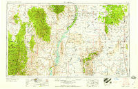
~ Tularosa NM topo map, 1:250000 scale, 1 X 2 Degree, Historical, 1958
Tularosa, New Mexico, USGS topographic map dated 1958.
Includes geographic coordinates (latitude and longitude). This topographic map is suitable for hiking, camping, and exploring, or framing it as a wall map.
Printed on-demand using high resolution imagery, on heavy weight and acid free paper, or alternatively on a variety of synthetic materials.
Topos available on paper, Waterproof, Poly, or Tyvek. Usually shipping rolled, unless combined with other folded maps in one order.
- Product Number: USGS-5386558
- Free digital map download (high-resolution, GeoPDF): Tularosa, New Mexico (file size: 19 MB)
- Map Size: please refer to the dimensions of the GeoPDF map above
- Weight (paper map): ca. 55 grams
- Map Type: POD USGS Topographic Map
- Map Series: HTMC
- Map Verison: Historical
- Cell ID: 69063
- Scan ID: 193409
- Woodland Tint: Yes
- Visual Version Number: 1
- Field Check Year: 1954
- Datum: Unstated
- Map Projection: Transverse Mercator
- Map published by United States Geological Survey
- Map published by United States Army Corps of Engineers
- Map published by United States Army
- Map Language: English
- Scanner Resolution: 600 dpi
- Map Cell Name: Tularosa
- Grid size: 1 X 2 Degree
- Date on map: 1958
- Map Scale: 1:250000
- Geographical region: New Mexico, United States
Neighboring Maps:
All neighboring USGS topo maps are available for sale online at a variety of scales.
Spatial coverage:
Topo map Tularosa, New Mexico, covers the geographical area associated the following places:
- Luis Lopez - Franks Place - Elephant Butte Estates - Old Carthage - Val Verde - Chloride - Coane - Kline Place - Jornada - San Marcial - Williamsburg - Santana Place - Dusty (historical) - Cherryville (historical) - Garcia Place - Kimmons - Laborcita - Dusty - Hot Springs Landing - Chise - Engle - Salinas - Las Palomas - Hard Luck Crossing - San Pedro - Tularosa - Oscura - Elephant Butte - Rouse Place - Paraje (historical) - Kinney Wells - Tiffany - Truth or Consequences - San Antonio - Murphy Place - Francisco Rascon Place - Tokay - Cora Crew - Monticello - Bloodgood Place - La Petra - Rosedale (historical) - Cuchillo - Adobe Ranch - Satathite Place - Mill Place - Jewkes Place - Dusty - Grafton - Lovelace - Crocker - Lava - Hermosa - Roberson Place - Monica (historical) - Chaves Place - Winston - Morine Place - Carthage - Rock Canyon - Craig (historical) - Cutter - Bosquecito - Bingham - San Antonito - Three Rivers - Placitas
- Map Area ID: AREA3433-108-106
- Northwest corner Lat/Long code: USGSNW34-108
- Northeast corner Lat/Long code: USGSNE34-106
- Southwest corner Lat/Long code: USGSSW33-108
- Southeast corner Lat/Long code: USGSSE33-106
- Northern map edge Latitude: 34
- Southern map edge Latitude: 33
- Western map edge Longitude: -108
- Eastern map edge Longitude: -106


