
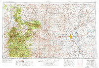
~ Roswell NM topo map, 1:250000 scale, 1 X 2 Degree, Historical, 1955, updated 1974
Roswell, New Mexico, USGS topographic map dated 1955.
Includes geographic coordinates (latitude and longitude). This topographic map is suitable for hiking, camping, and exploring, or framing it as a wall map.
Printed on-demand using high resolution imagery, on heavy weight and acid free paper, or alternatively on a variety of synthetic materials.
Topos available on paper, Waterproof, Poly, or Tyvek. Usually shipping rolled, unless combined with other folded maps in one order.
- Product Number: USGS-5386502
- Free digital map download (high-resolution, GeoPDF): Roswell, New Mexico (file size: 22 MB)
- Map Size: please refer to the dimensions of the GeoPDF map above
- Weight (paper map): ca. 55 grams
- Map Type: POD USGS Topographic Map
- Map Series: HTMC
- Map Verison: Historical
- Cell ID: 68994
- Scan ID: 192120
- Imprint Year: 1974
- Woodland Tint: Yes
- Visual Version Number: 2
- Aerial Photo Year: 1971
- Edit Year: 1972
- Datum: Unstated
- Map Projection: Transverse Mercator
- Map published by United States Geological Survey
- Map Language: English
- Scanner Resolution: 600 dpi
- Map Cell Name: Roswell
- Grid size: 1 X 2 Degree
- Date on map: 1955
- Map Scale: 1:250000
- Geographical region: New Mexico, United States
Neighboring Maps:
All neighboring USGS topo maps are available for sale online at a variety of scales.
Spatial coverage:
Topo map Roswell, New Mexico, covers the geographical area associated the following places:
- Ramsdale Place - Chisum - Alamorosa - Roswell - Mossman - McDermott Wells - South Spring Acres - Bent - Frazier (historical) - Olive - Largo - Arabela - Nogal - Ponderosa Heights - Elkins - Missouri Plaza (historical) - Lincoln - Escondido (historical) - Apache - Alpine Cellars Village - Blazers Mill - Tinnie - Blackdom (historical) - Pine Lodge - Baca (historical) - Ancho - Carrizozo - Picacho - Bonito - Hollywood - Vera Cruz (historical) - Hagerman - Angus - Silver Springs - San Patricio - Alto - Manchester (historical) - Coalora - Sun Valley - Mescalero - Hondo - Capitan - Encinoso - East Grand Plains - Center Mill - South Mill - Whitetail - Sunset - Villa Madonna - Reventon - White Oaks - Polly - Higgins Place - Fairbanks - Deering Place - Fort Stanton - Melena - South Spring - Glencoe - Campbell - Bluewater - Ruidoso - Berrendo (historical) - Carrizo - Riverside - Highway Mill - Midway - Luna - Jicarilla - Sherman Place - Dexter - Mountain View - Sierra Vista - Diamante Mill - Robsart - Acme - Ruidoso Downs - River Mill - Loving Place - Greenfield - Mesa - Coyote - Cooper - Double Crossing - Lake Van
- Map Area ID: AREA3433-106-104
- Northwest corner Lat/Long code: USGSNW34-106
- Northeast corner Lat/Long code: USGSNE34-104
- Southwest corner Lat/Long code: USGSSW33-106
- Southeast corner Lat/Long code: USGSSE33-104
- Northern map edge Latitude: 34
- Southern map edge Latitude: 33
- Western map edge Longitude: -106
- Eastern map edge Longitude: -104


