
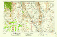
~ Las Cruces NM topo map, 1:250000 scale, 1 X 2 Degree, Historical, 1958
Las Cruces, New Mexico, USGS topographic map dated 1958.
Includes geographic coordinates (latitude and longitude). This topographic map is suitable for hiking, camping, and exploring, or framing it as a wall map.
Printed on-demand using high resolution imagery, on heavy weight and acid free paper, or alternatively on a variety of synthetic materials.
Topos available on paper, Waterproof, Poly, or Tyvek. Usually shipping rolled, unless combined with other folded maps in one order.
- Product Number: USGS-5386476
- Free digital map download (high-resolution, GeoPDF): Las Cruces, New Mexico (file size: 17 MB)
- Map Size: please refer to the dimensions of the GeoPDF map above
- Weight (paper map): ca. 55 grams
- Map Type: POD USGS Topographic Map
- Map Series: HTMC
- Map Verison: Historical
- Cell ID: 72235
- Scan ID: 191241
- Woodland Tint: Yes
- Aerial Photo Year: 1948
- Field Check Year: 1954
- Datum: Unstated
- Map Projection: Transverse Mercator
- Map published by United States Geological Survey
- Map Language: English
- Scanner Resolution: 600 dpi
- Map Cell Name: Las Cruces
- Grid size: 1 X 2 Degree
- Date on map: 1958
- Map Scale: 1:250000
- Geographical region: New Mexico, United States
Neighboring Maps:
All neighboring USGS topo maps are available for sale online at a variety of scales.
Spatial coverage:
Topo map Las Cruces, New Mexico, covers the geographical area associated the following places:
- Garfield - University Park - Tortugas - San Juan - Peruhill - Mesquite - Alivio - Dwyer - Sherman - Doña Ana - Mesilla - Caballo - Point of Sands - Chaparral - Orogrande - San Pablo - Fairacres - Rincon - Eller Place - Carne - Vado - Elwood - Tunis - Hockett - White Sands - Spalding - Las Cruces - Turquoise - Sunshine - Berino - Chaparral - San Miguel - Big Mill - Fort Selden - Radium Springs - Hatch - Rodey - Cambray - Boyd - Santo Tomas - Angostura - Hill - Kingston - Chamberino - Myndus - Mirage - Arrey - Organ - Nutt - Anthony - Old Town - Hersey Place - Modoc (historical) - Kimball Place - Grama - Placitas - Picacho - Mimbres - Florida - Chappel - Mesilla Park - San Lorenzo - Upham - Oasis - Monista (historical) - Rutter - Deming - Salem - La Mesa - Four Points - Lake Valley - El Ojito - Akela - Hillsboro - Spaceport City - Tonuco - Pronto - Alvarado - Afton - Aden - Leasburg - Newman - Hacienda Acres - Derry - Kenzin - San Ysidro - Mountain View
- Map Area ID: AREA3332-108-106
- Northwest corner Lat/Long code: USGSNW33-108
- Northeast corner Lat/Long code: USGSNE33-106
- Southwest corner Lat/Long code: USGSSW32-108
- Southeast corner Lat/Long code: USGSSE32-106
- Northern map edge Latitude: 33
- Southern map edge Latitude: 32
- Western map edge Longitude: -108
- Eastern map edge Longitude: -106


