
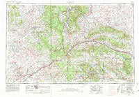
~ Gallup NM topo map, 1:250000 scale, 1 X 2 Degree, Historical, 1954, updated 1981
Gallup, New Mexico, USGS topographic map dated 1954.
Includes geographic coordinates (latitude and longitude). This topographic map is suitable for hiking, camping, and exploring, or framing it as a wall map.
Printed on-demand using high resolution imagery, on heavy weight and acid free paper, or alternatively on a variety of synthetic materials.
Topos available on paper, Waterproof, Poly, or Tyvek. Usually shipping rolled, unless combined with other folded maps in one order.
- Product Number: USGS-5386466
- Free digital map download (high-resolution, GeoPDF): Gallup, New Mexico (file size: 21 MB)
- Map Size: please refer to the dimensions of the GeoPDF map above
- Weight (paper map): ca. 55 grams
- Map Type: POD USGS Topographic Map
- Map Series: HTMC
- Map Verison: Historical
- Cell ID: 74969
- Scan ID: 190730
- Imprint Year: 1981
- Woodland Tint: Yes
- Visual Version Number: 1
- Photo Revision Year: 1970
- Aerial Photo Year: 1954
- Edit Year: 1970
- Field Check Year: 1954
- Datum: NAD27
- Map Projection: Transverse Mercator
- Map published by United States Geological Survey
- Map Language: English
- Scanner Resolution: 600 dpi
- Map Cell Name: Gallup
- Grid size: 1 X 2 Degree
- Date on map: 1954
- Map Scale: 1:250000
- Geographical region: New Mexico, United States
Neighboring Maps:
All neighboring USGS topo maps are available for sale online at a variety of scales.
Spatial coverage:
Topo map Gallup, New Mexico, covers the geographical area associated the following places:
- Bonita Trading Post - Fort Wingate - Tohatchi - Mexican Springs - Allison - Greasewood - Heaton (historical) - Wide Ruins - Gonzales - Gallup - Ciniza - South Chaves - Chambers - Lower Nutria - Yah-ta-hey - Ganado - Tse Bonito - Rehoboth - Steamboat Canyon - Polich Place - Pueblito - Gibson (historical) - Perea - Nazlini - Page - Standing Rock - Pinehaven - Mariano Lake - Cornfields - Defiance - Weaver (historical) - Grubisich Place - Zuni - Window Rock - Woodspring Trading Post - Prewitt - Wood Springs - Sand Corner - Tsintaa Yiti Ii - Tanner Springs - Oak Springs - Smith Lake - Steamboat - Shillingburg (historical) - Church Rock - Thoreau - Buffalo Springs - Tekapo - Sundance - Gibson (historical) - North Chaves - Upper Nutria - El Morro - Diener - Wingate - Vanderwagen - Rock Springs - Zuni - Tinaja - Copperton - Sawyer - Navajo - McCune - Sawmill - South Guam - Saint Michaels - Iyanbito - Fort Defiance - Zuni Pueblo - Manuelito - Allentown - Lupton - Sunrise Springs - Pine Springs - Brimhall Nizhoni - Gamerco - Houck - El Morro - Boon Place - North Guam - Pescado - Bread Springs - Crownpoint - Coyote Canyon - Klagetoh - Mentmore - Twin Lakes - Burnside - Continental Divide - Hunters Point - Chi Chil Tah - Red Rock - Chetco - Navajo - Navarre Place - Black Rock - Sanchez Place - Sanders - McGaffey - Pinedale
- Map Area ID: AREA3635-110-108
- Northwest corner Lat/Long code: USGSNW36-110
- Northeast corner Lat/Long code: USGSNE36-108
- Southwest corner Lat/Long code: USGSSW35-110
- Southeast corner Lat/Long code: USGSSE35-108
- Northern map edge Latitude: 36
- Southern map edge Latitude: 35
- Western map edge Longitude: -110
- Eastern map edge Longitude: -108


