
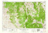
~ Aztec NM topo map, 1:250000 scale, 1 X 2 Degree, Historical, 1962
Aztec, New Mexico, USGS topographic map dated 1962.
Includes geographic coordinates (latitude and longitude). This topographic map is suitable for hiking, camping, and exploring, or framing it as a wall map.
Printed on-demand using high resolution imagery, on heavy weight and acid free paper, or alternatively on a variety of synthetic materials.
Topos available on paper, Waterproof, Poly, or Tyvek. Usually shipping rolled, unless combined with other folded maps in one order.
- Product Number: USGS-5386422
- Free digital map download (high-resolution, GeoPDF): Aztec, New Mexico (file size: 22 MB)
- Map Size: please refer to the dimensions of the GeoPDF map above
- Weight (paper map): ca. 55 grams
- Map Type: POD USGS Topographic Map
- Map Series: HTMC
- Map Verison: Historical
- Cell ID: 68657
- Scan ID: 189671
- Woodland Tint: Yes
- Aerial Photo Year: 1953
- Field Check Year: 1954
- Survey Year: 1960
- Datum: Unstated
- Map Projection: Transverse Mercator
- Map published by United States Geological Survey
- Map Language: English
- Scanner Resolution: 600 dpi
- Map Cell Name: Aztec
- Grid size: 1 X 2 Degree
- Date on map: 1962
- Map Scale: 1:250000
- Geographical region: New Mexico, United States
Neighboring Maps:
All neighboring USGS topo maps are available for sale online at a variety of scales.
Spatial coverage:
Topo map Aztec, New Mexico, covers the geographical area associated the following places:
- Mullen Place - Amargo - Fairview - Lobato - Duranes - Plaza Blanca - Chamita - Estaca - Chama - Chili - Dulce - Inca - Aztec - Los Pinos - Garcia Place - Vallecitos - San Juan Pueblo - Lybrook - Barranca - Alcalde - Coyote - Wright Place - Young Place - Counselor - Los Ojos - Copper City (historical) - Fivemile Crossing - Santo Niño - Ojo Caliente - El Monte Rojo - La Chuachia - La Villita - Regina - La Puente - Pueblito - La Careda - Arroyo del Agua - Abiquiu - Llaves - La Madera - Riverside - Alire - El Vado - Navajo - Ulibarri Place - Vaqueros (historical) - La Placita - Las Tablas - Las Placitas - Tierra Azul - Blanco - El Duende - Cebolla - San Jose - Ensenada - Navajo City - Jarosa - Capulin - La Jara - Gallina - Lower Cañones - Clara Peak - Diamante (historical) - Tapicitoes - Ancones - Crowther Cow Camp - Monero - Self Place - La Madera - Petaca - Lindrith - San Miguel - Vallecitos Corrales - Pounds (historical) - Frijoles Spring - Willow Creek - Mackey Place - Brazos - Los Luceros - Lucero Place - Alcatraz - Biggs (historical) - Medanales - Gallegos - Ojito - Archuleta - Buena Vista - Carracas - El Llano - Turley - Christopher Place - El Rito - Placitas - Lyden - Las Nutrias - Cañones - Kimbeto - Lava - Garrison - Santa Teresa
- Map Area ID: AREA3736-108-106
- Northwest corner Lat/Long code: USGSNW37-108
- Northeast corner Lat/Long code: USGSNE37-106
- Southwest corner Lat/Long code: USGSSW36-108
- Southeast corner Lat/Long code: USGSSE36-106
- Northern map edge Latitude: 37
- Southern map edge Latitude: 36
- Western map edge Longitude: -108
- Eastern map edge Longitude: -106


