
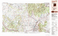
~ Albuquerque NM topo map, 1:250000 scale, 1 X 2 Degree, Historical, 1983, updated 1984
Albuquerque, New Mexico, USGS topographic map dated 1983.
Includes geographic coordinates (latitude and longitude). This topographic map is suitable for hiking, camping, and exploring, or framing it as a wall map.
Printed on-demand using high resolution imagery, on heavy weight and acid free paper, or alternatively on a variety of synthetic materials.
Topos available on paper, Waterproof, Poly, or Tyvek. Usually shipping rolled, unless combined with other folded maps in one order.
- Product Number: USGS-5386414
- Free digital map download (high-resolution, GeoPDF): Albuquerque, New Mexico (file size: 23 MB)
- Map Size: please refer to the dimensions of the GeoPDF map above
- Weight (paper map): ca. 55 grams
- Map Type: POD USGS Topographic Map
- Map Series: HTMC
- Map Verison: Historical
- Cell ID: 68640
- Scan ID: 189547
- Imprint Year: 1984
- Woodland Tint: Yes
- Aerial Photo Year: 1980
- Edit Year: 1983
- Datum: NAD27
- Map Projection: Universal Transverse Mercator
- Map published by United States Geological Survey
- Map Language: English
- Scanner Resolution: 600 dpi
- Map Cell Name: Albuquerque
- Grid size: 1 X 2 Degree
- Date on map: 1983
- Map Scale: 1:250000
- Geographical region: New Mexico, United States
Neighboring Maps:
All neighboring USGS topo maps are available for sale online at a variety of scales.
Spatial coverage:
Topo map Albuquerque, New Mexico, covers the geographical area associated the following places:
- Sulphur Springs - Kirtland Addition - Vista de Oro de Placitas - Sierra Vista Estates - West Village - South Valley - Cochiti Pueblo - Vista Encantada - Kinney - Anasazi Trails - Lee Acres - Sandia Vista - Bland - Gallegos - San Pedro - Pinon Ridge Estates - Casa Loma - Frost (historical) - Cedro - Las Colonias - Albuquerque - Old Town - Cuyamungue - Guachupangue - Five Points - Las Dos - Cedar Grove - Pajarito - Cabezon - Madrid - Rosario - Las Cocinitas (historical) - Barelas - Herrera - San Jose - Sandia Knolls - Toltec - Marquez - Grants - Piedra de la Aguila - Budville - Los Alamos - Acomita - Los Pastores - Seama - Canyon Estates - Casa Salazar - Arroyo Seco - San Antonito - Angostura - Sandia Pueblo - Sombrillo - Bonanza City (historical) - LaVentana - Horton Place - Los Pinos - Los Ranchos de Albuquerque - Cañoncito - La Cuesta - Ranchito - Whitehorse - Cedar Crest - Puertecito - Hoffmantown - Gilman - Española - Martin Place - Rancho Valle - Coyote (historical) - Montezuma (historical) - Puesta Del Sol - Santo Domingo Pueblo - Taylor Ranch - Deer Lake - Sandia Heights - Ponderosa - Marmon - Barton - Pueblo Pintado - Peña Blanca - Deer Creek Landing - O'Neil Landing - Primera Agua - Forest Park - Atrisco - Casa Fria - Cañon - Moquino - Domingo - San Pedro - Seven Springs - Arenal - San Pedro Overlook - San Felipe Pueblo - Ojo Encino - Santa Clara - Tijeras - Acomita Lake - Rio Rancho - Santa Ana Pueblo
- Map Area ID: AREA3635-108-106
- Northwest corner Lat/Long code: USGSNW36-108
- Northeast corner Lat/Long code: USGSNE36-106
- Southwest corner Lat/Long code: USGSSW35-108
- Southeast corner Lat/Long code: USGSSE35-106
- Northern map edge Latitude: 36
- Southern map edge Latitude: 35
- Western map edge Longitude: -108
- Eastern map edge Longitude: -106


