
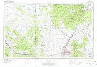
~ Albuquerque NM topo map, 1:250000 scale, 1 X 2 Degree, Historical, 1963, updated 1971
Albuquerque, New Mexico, USGS topographic map dated 1963.
Includes geographic coordinates (latitude and longitude). This topographic map is suitable for hiking, camping, and exploring, or framing it as a wall map.
Printed on-demand using high resolution imagery, on heavy weight and acid free paper, or alternatively on a variety of synthetic materials.
Topos available on paper, Waterproof, Poly, or Tyvek. Usually shipping rolled, unless combined with other folded maps in one order.
- Product Number: USGS-5386412
- Free digital map download (high-resolution, GeoPDF): Albuquerque, New Mexico (file size: 15 MB)
- Map Size: please refer to the dimensions of the GeoPDF map above
- Weight (paper map): ca. 55 grams
- Map Type: POD USGS Topographic Map
- Map Series: HTMC
- Map Verison: Historical
- Cell ID: 68640
- Scan ID: 189543
- Imprint Year: 1971
- Woodland Tint: Yes
- Aerial Photo Year: 1963
- Field Check Year: 1963
- Survey Year: 1961
- Datum: NAD27
- Map Projection: Universal Transverse Mercator
- Map published by United States Geological Survey
- Map Language: English
- Scanner Resolution: 600 dpi
- Map Cell Name: Albuquerque
- Grid size: 1 X 2 Degree
- Date on map: 1963
- Map Scale: 1:250000
- Geographical region: New Mexico, United States
Neighboring Maps:
All neighboring USGS topo maps are available for sale online at a variety of scales.
Spatial coverage:
Topo map Albuquerque, New Mexico, covers the geographical area associated the following places:
- Santa Clara Pueblo - Lagunitas - La Bajada - Zia Pueblo - White Rock - El Tablazon - Dennis Chaves Estates - San Fidel - Cochiti Pueblo - Otto - Kemp (historical) - Rio Rancho Estates - Ranchos des Placitas - Cebolletita - Chical - La Madera - Bibo - El Llanito - Deer Lake - Cerrillos - Kinney - Waldo (historical) - Jarett Place - Puesta Del Sol - Quarteles - Monticello - Porter - Santo Nino - Anzac - Gilman - San Antonio - Herrera - Cieneguilla - Totavi - Primera Agua - Hoffmantown - San Miguel - Cañon - Sandia Vista - Las Cocinitas (historical) - Forest Park - Pueblo Pintado - Marmon - Peña Blanca - Ranchito - Atrisco - Buena Ventura - Bernalillo - Sierra de los Pinos - Lee Acres - Ambrosia Lake - Alameda - San Pedro - Montezuma (historical) - Pojoaque - Sandia Pueblo - P Simmons Place - Taylor Ranch - Placitas - Rivajana - Desert Mountain - Paradise Hills - North Acomita Village - Las Colonias - Cañada Village - La Cueva - Sandia Heights - Gallegos - Piedra de la Aguila - Los Pinos - Tinian - Vista Encantada - San Ysidro - Martinez Town - Armijo - El Chapparal - San Pedro Overlook - Santa Ana Pueblo - Jaconita - Puertecito - Whitehorse - Guadalupe - McCartys - Ortiz (historical) - Johns Place - Juan Tomas - Madrid - Philadelphia - West Village - Corrales - Moquino - Seboyeta - Jemez Pueblo - Santo Domingo Pueblo - Diamond Tail Ranch - Los Cerrilos - Old Town - Seama - Horton Place - Toltec
- Map Area ID: AREA3635-108-106
- Northwest corner Lat/Long code: USGSNW36-108
- Northeast corner Lat/Long code: USGSNE36-106
- Southwest corner Lat/Long code: USGSSW35-108
- Southeast corner Lat/Long code: USGSSE35-106
- Northern map edge Latitude: 36
- Southern map edge Latitude: 35
- Western map edge Longitude: -108
- Eastern map edge Longitude: -106


