
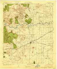
~ Tucumcari NM topo map, 1:125000 scale, 30 X 30 Minute, Historical, 1930
Tucumcari, New Mexico, USGS topographic map dated 1930.
Includes geographic coordinates (latitude and longitude). This topographic map is suitable for hiking, camping, and exploring, or framing it as a wall map.
Printed on-demand using high resolution imagery, on heavy weight and acid free paper, or alternatively on a variety of synthetic materials.
Topos available on paper, Waterproof, Poly, or Tyvek. Usually shipping rolled, unless combined with other folded maps in one order.
- Product Number: USGS-5386382
- Free digital map download (high-resolution, GeoPDF): Tucumcari, New Mexico (file size: 8 MB)
- Map Size: please refer to the dimensions of the GeoPDF map above
- Weight (paper map): ca. 55 grams
- Map Type: POD USGS Topographic Map
- Map Series: HTMC
- Map Verison: Historical
- Cell ID: 66817
- Scan ID: 189433
- Woodland Tint: Yes
- Survey Year: 1928
- Datum: NAD
- Map Projection: Polyconic
- Map published by United States Geological Survey
- Map Language: English
- Scanner Resolution: 600 dpi
- Map Cell Name: Tucumcari
- Grid size: 30 X 30 Minute
- Date on map: 1930
- Map Scale: 1:125000
- Geographical region: New Mexico, United States
Neighboring Maps:
All neighboring USGS topo maps are available for sale online at a variety of scales.
Spatial coverage:
Topo map Tucumcari, New Mexico, covers the geographical area associated the following places:
- Hargis - Palomas - Hanley (historical) - Lesbia - Tucumcari - Frio (historical) - Hudson
- Map Area ID: AREA35.535-104-103.5
- Northwest corner Lat/Long code: USGSNW35.5-104
- Northeast corner Lat/Long code: USGSNE35.5-103.5
- Southwest corner Lat/Long code: USGSSW35-104
- Southeast corner Lat/Long code: USGSSE35-103.5
- Northern map edge Latitude: 35.5
- Southern map edge Latitude: 35
- Western map edge Longitude: -104
- Eastern map edge Longitude: -103.5


