
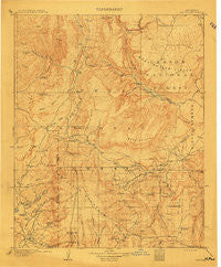
~ Gallina NM topo map, 1:125000 scale, 30 X 30 Minute, Historical, 1909
Gallina, New Mexico, USGS topographic map dated 1909.
Includes geographic coordinates (latitude and longitude). This topographic map is suitable for hiking, camping, and exploring, or framing it as a wall map.
Printed on-demand using high resolution imagery, on heavy weight and acid free paper, or alternatively on a variety of synthetic materials.
Topos available on paper, Waterproof, Poly, or Tyvek. Usually shipping rolled, unless combined with other folded maps in one order.
- Product Number: USGS-5386264
- Free digital map download (high-resolution, GeoPDF): Gallina, New Mexico (file size: 8 MB)
- Map Size: please refer to the dimensions of the GeoPDF map above
- Weight (paper map): ca. 55 grams
- Map Type: POD USGS Topographic Map
- Map Series: HTMC
- Map Verison: Historical
- Cell ID: 65539
- Scan ID: 189325
- Survey Year: 1907
- Datum: Unstated
- Map Projection: Unstated
- Map published by United States Geological Survey
- Map Language: English
- Scanner Resolution: 600 dpi
- Map Cell Name: Gallina
- Grid size: 30 X 30 Minute
- Date on map: 1909
- Map Scale: 1:125000
- Geographical region: New Mexico, United States
Neighboring Maps:
All neighboring USGS topo maps are available for sale online at a variety of scales.
Spatial coverage:
Topo map Gallina, New Mexico, covers the geographical area associated the following places:
- La Jara - Alire - Jarosa - La Placita - Upper La Jara - Coyote - Garrison - Youngsville - Cuba - Copper City (historical) - Santa Teresa - Llaves - Capulin - Rio Puerco - Gallina - Regina - Arroyo del Agua
- Map Area ID: AREA36.536-107-106.5
- Northwest corner Lat/Long code: USGSNW36.5-107
- Northeast corner Lat/Long code: USGSNE36.5-106.5
- Southwest corner Lat/Long code: USGSSW36-107
- Southeast corner Lat/Long code: USGSSE36-106.5
- Northern map edge Latitude: 36.5
- Southern map edge Latitude: 36
- Western map edge Longitude: -107
- Eastern map edge Longitude: -106.5


