
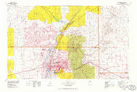
~ Albuquerque NM topo map, 1:100000 scale, 30 X 60 Minute, Historical, 1978, updated 1986
Albuquerque, New Mexico, USGS topographic map dated 1978.
Includes geographic coordinates (latitude and longitude). This topographic map is suitable for hiking, camping, and exploring, or framing it as a wall map.
Printed on-demand using high resolution imagery, on heavy weight and acid free paper, or alternatively on a variety of synthetic materials.
Topos available on paper, Waterproof, Poly, or Tyvek. Usually shipping rolled, unless combined with other folded maps in one order.
- Product Number: USGS-5386058
- Free digital map download (high-resolution, GeoPDF): Albuquerque, New Mexico (file size: 24 MB)
- Map Size: please refer to the dimensions of the GeoPDF map above
- Weight (paper map): ca. 55 grams
- Map Type: POD USGS Topographic Map
- Map Series: HTMC
- Map Verison: Historical
- Cell ID: 67026
- Scan ID: 189546
- Imprint Year: 1986
- Aerial Photo Year: 1976
- Edit Year: 1978
- Datum: NAD27
- Map Projection: Universal Transverse Mercator
- Map published by United States Geological Survey
- Map Language: English
- Scanner Resolution: 600 dpi
- Map Cell Name: Albuquerque
- Grid size: 30 X 60 Minute
- Date on map: 1978
- Map Scale: 1:100000
- Geographical region: New Mexico, United States
Neighboring Maps:
All neighboring USGS topo maps are available for sale online at a variety of scales.
Spatial coverage:
Topo map Albuquerque, New Mexico, covers the geographical area associated the following places:
- Canyon Estates - Rio Rancho Estates - Tinen Place - Las Cocinitas (historical) - Casa Loma - Frost (historical) - P Simmons Place - Hagan (historical) - La Cuesta - Forest Park - Briggs Place - Pueblo of Sandia Village - Puesta Del Sol - Angostura - Sandia Pueblo - San Pedro Creek - Paako Communities - Primera Agua - Rivajana - Old Town - North Valley - Juan Tomas - San Felipe Pueblo - Barelas - Santa Ana Pueblo - Barton - Las Huertas - Carnuel - Cerrillos - Albuquerque - Cedro - Horton Place - Dennis Chaves Estates - Hoffmantown - Tecolote - Fruitvale (historical) - Gallegos - Kinney - Vista Encantada - Evergreen Hills Subdivision - Tierra Monte Subdivision - Martin Place - Five Points - Ranchito - Buena Ventura - San Jose - Rio Rancho - Village de las Huertas - Otto - Tijeras - Rosario - El Llanito - Hyer - Montezuma (historical) - San Pedro - Ortiz (historical) - Sierra Vista Estates - Madrid - Algodones - Desert Mountain - Zamora - El Tablazon - Monticello - Sandia Knolls - Johns Place - Vista de Oro de Placitas - Corrales - Ranchos des Placitas - Corners - Jarett Place - South Valley - Los Ranchos de Albuquerque - Atrisco - Sandia Park - Dennison Place - Bernalillo - Cañada Village - Las Colonias - Kirtland Addition - Sandia Heights - Hahn - San Antonio - Agua (historical) - Taylor Ranch - Sedillo - The Overlook - Sandia Vista - Pinon Ridge Estates - Lee Acres - Tejon (historical) - El Refugio - San Antonito - Golden - Magic Valley - Placitas Homesteads - Chelwood Park - El Chapparal - Los Candelarias - Dolores (historical) - Chical
- Map Area ID: AREA35.535-107-106
- Northwest corner Lat/Long code: USGSNW35.5-107
- Northeast corner Lat/Long code: USGSNE35.5-106
- Southwest corner Lat/Long code: USGSSW35-107
- Southeast corner Lat/Long code: USGSSE35-106
- Northern map edge Latitude: 35.5
- Southern map edge Latitude: 35
- Western map edge Longitude: -107
- Eastern map edge Longitude: -106


