
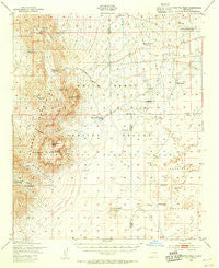
~ Capitol Peak NM topo map, 1:62500 scale, 15 X 15 Minute, Historical, 1947, updated 1955
Capitol Peak, New Mexico, USGS topographic map dated 1947.
Includes geographic coordinates (latitude and longitude). This topographic map is suitable for hiking, camping, and exploring, or framing it as a wall map.
Printed on-demand using high resolution imagery, on heavy weight and acid free paper, or alternatively on a variety of synthetic materials.
Topos available on paper, Waterproof, Poly, or Tyvek. Usually shipping rolled, unless combined with other folded maps in one order.
- Product Number: USGS-5385396
- Free digital map download (high-resolution, GeoPDF): Capitol Peak, New Mexico (file size: 7 MB)
- Map Size: please refer to the dimensions of the GeoPDF map above
- Weight (paper map): ca. 55 grams
- Map Type: POD USGS Topographic Map
- Map Series: HTMC
- Map Verison: Historical
- Cell ID: 52164
- Scan ID: 190011
- Imprint Year: 1955
- Visual Version Number: 2
- Aerial Photo Year: 1948
- Field Check Year: 1947
- Datum: NAD27
- Map Projection: Polyconic
- Map published by United States Army Corps of Engineers
- Map Language: English
- Scanner Resolution: 600 dpi
- Map Cell Name: Capitol Peak
- Grid size: 15 X 15 Minute
- Date on map: 1947
- Map Scale: 1:62500
- Geographical region: New Mexico, United States
Neighboring Maps:
All neighboring USGS topo maps are available for sale online at a variety of scales.
Spatial coverage:
Topo map Capitol Peak, New Mexico, covers the geographical area associated the following places:
- Lower Well - Malpais Spring - Short Well - Mine Tank - South Well - Johnson Park Canyon - Joe West Tank - Basso Four Mine - Mayday Number 3 - Lee Canyon - Cains Ranch (historical) - Section 29 Prospect - Red Hill - Gilliland North Well - May Day Number 1 Claim - Capitol Peak - Mockingbird Gap Mine - Lee Canyon Spring - Juniper Well - Mexican Hat Spring - Salt Springs - Upper Dog Town Tank - Baso Four - Hays Gap - Johnson Park - Baso Four Deposit - Mound Springs - Salina de San Andres - Thurgood Canyon - Hayfield Well - Sheep Mountain - Lone Cedar Tank - Sheep Mountain Spring - Capitol Peak Tank - Gililland South Ranch (historical) - CCC Tank - Big Tank - Sly Canyon - Sly Gap - Lava Gap - Line Tank - Section 29 - Thoroughgood Canyon - Red Tank - Mac Water Well - B E Edwards Number 127 - Mayday Number 2 - Burris Well - Mockingbird Gap
- Map Area ID: AREA33.533.25-106.5-106.25
- Northwest corner Lat/Long code: USGSNW33.5-106.5
- Northeast corner Lat/Long code: USGSNE33.5-106.25
- Southwest corner Lat/Long code: USGSSW33.25-106.5
- Southeast corner Lat/Long code: USGSSE33.25-106.25
- Northern map edge Latitude: 33.5
- Southern map edge Latitude: 33.25
- Western map edge Longitude: -106.5
- Eastern map edge Longitude: -106.25


