
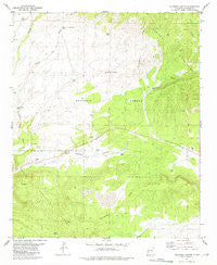
~ Tularosa Canyon NM topo map, 1:24000 scale, 7.5 X 7.5 Minute, Historical, 1981, updated 1981
Tularosa Canyon, New Mexico, USGS topographic map dated 1981.
Includes geographic coordinates (latitude and longitude). This topographic map is suitable for hiking, camping, and exploring, or framing it as a wall map.
Printed on-demand using high resolution imagery, on heavy weight and acid free paper, or alternatively on a variety of synthetic materials.
Topos available on paper, Waterproof, Poly, or Tyvek. Usually shipping rolled, unless combined with other folded maps in one order.
- Product Number: USGS-5384646
- Free digital map download (high-resolution, GeoPDF): Tularosa Canyon, New Mexico (file size: 11 MB)
- Map Size: please refer to the dimensions of the GeoPDF map above
- Weight (paper map): ca. 55 grams
- Map Type: POD USGS Topographic Map
- Map Series: HTMC
- Map Verison: Historical
- Cell ID: 45899
- Scan ID: 193399
- Imprint Year: 1981
- Woodland Tint: Yes
- Aerial Photo Year: 1967
- Edit Year: 1981
- Field Check Year: 1975
- Datum: NAD27
- Map Projection: Transverse Mercator
- Map published by United States Geological Survey
- Map Language: English
- Scanner Resolution: 600 dpi
- Map Cell Name: Tularosa Canyon
- Grid size: 7.5 X 7.5 Minute
- Date on map: 1981
- Map Scale: 1:24000
- Geographical region: New Mexico, United States
Neighboring Maps:
All neighboring USGS topo maps are available for sale online at a variety of scales.
Spatial coverage:
Topo map Tularosa Canyon, New Mexico, covers the geographical area associated the following places:
- Dog Tank - 10007 Water Well - Aragon Water Well - Lambing Camp Tank - Thomas Tank - Upper Canondel Buey Tank - Road Forks Tank - West Well - Patterson Pond - GC Number Six Tank - Fence Tank - GC Number Seven Tank - Tularosa Shipping Corrals - Attavesudo Tank - Poacher Tank - Jackson Well - Tularosa Canyon - Sand Flat Canyon - South Tank - Willow Tank - Indio Canyon - Lopez Spring - Celso Spring - Sand Flats - Miner Water Well - Rock Tank - Canon del Buey - Catron County
- Map Area ID: AREA3433.875-108.5-108.375
- Northwest corner Lat/Long code: USGSNW34-108.5
- Northeast corner Lat/Long code: USGSNE34-108.375
- Southwest corner Lat/Long code: USGSSW33.875-108.5
- Southeast corner Lat/Long code: USGSSE33.875-108.375
- Northern map edge Latitude: 34
- Southern map edge Latitude: 33.875
- Western map edge Longitude: -108.5
- Eastern map edge Longitude: -108.375


