
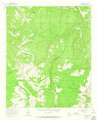
~ Saliz Pass NM topo map, 1:24000 scale, 7.5 X 7.5 Minute, Historical, 1963, updated 1965
Saliz Pass, New Mexico, USGS topographic map dated 1963.
Includes geographic coordinates (latitude and longitude). This topographic map is suitable for hiking, camping, and exploring, or framing it as a wall map.
Printed on-demand using high resolution imagery, on heavy weight and acid free paper, or alternatively on a variety of synthetic materials.
Topos available on paper, Waterproof, Poly, or Tyvek. Usually shipping rolled, unless combined with other folded maps in one order.
- Product Number: USGS-5383409
- Free digital map download (high-resolution, GeoPDF): Saliz Pass, New Mexico (file size: 11 MB)
- Map Size: please refer to the dimensions of the GeoPDF map above
- Weight (paper map): ca. 55 grams
- Map Type: POD USGS Topographic Map
- Map Series: HTMC
- Map Verison: Historical
- Cell ID: 39474
- Scan ID: 192154
- Imprint Year: 1965
- Woodland Tint: Yes
- Aerial Photo Year: 1958
- Field Check Year: 1963
- Datum: NAD27
- Map Projection: Polyconic
- Map published by United States Geological Survey
- Map Language: English
- Scanner Resolution: 600 dpi
- Map Cell Name: Saliz Pass
- Grid size: 7.5 X 7.5 Minute
- Date on map: 1963
- Map Scale: 1:24000
- Geographical region: New Mexico, United States
Neighboring Maps:
All neighboring USGS topo maps are available for sale online at a variety of scales.
Spatial coverage:
Topo map Saliz Pass, New Mexico, covers the geographical area associated the following places:
- Jones Canyon - Gordon Canyon - Brushy Canyon Corral - Buckskin Canyon - Saliz Hill - Martinez Ranch - Gut Ache Corral - Bang Tail Canyon - L Kelly Ranch - Javeling Tank - Chimney Rock - Chimney Rock Canyon - Kelly Camp - Brushy Well - River Tank - WS Corral - Willies Tank - Serna Ranch - Indian Peak Tank - Bear Canyon - Willie Kelly Place - Little Joe Tank - Bisquit Tank - Little Joe Trick Tank - Pup Canyon - Saliz Pass - Frying Pan Canyon - Dangerous Park Canyon - Upper Gut Ache Tank - Pueblo Park Spring - Lower Gut Ache Tank - Pueblo Park - Line Gap Tank - Saliz Corral - Brushy Mountains - West Fork Pueblo Creek - Cottonwood Campground - Cottonwood Canyon - Saliz Mountain Tank - Old Highway Tank - Kelly Tanks - Lewis Tank - Blue Range Wilderness - Pueblo Park Campground - Pueblo Park Corral - Tige Canyon - Brushy Canyon Tank - Bear Canyon Corral - Kelly Tank Number 2 - Ribbon Tank - Six Bar Tank - Gut Ache Mesa - Martinez Canyon
- Map Area ID: AREA33.62533.5-109-108.875
- Northwest corner Lat/Long code: USGSNW33.625-109
- Northeast corner Lat/Long code: USGSNE33.625-108.875
- Southwest corner Lat/Long code: USGSSW33.5-109
- Southeast corner Lat/Long code: USGSSE33.5-108.875
- Northern map edge Latitude: 33.625
- Southern map edge Latitude: 33.5
- Western map edge Longitude: -109
- Eastern map edge Longitude: -108.875


