
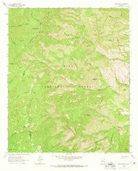
~ Reeds Peak NM topo map, 1:24000 scale, 7.5 X 7.5 Minute, Historical, 1963, updated 1965
Reeds Peak, New Mexico, USGS topographic map dated 1963.
Includes geographic coordinates (latitude and longitude). This topographic map is suitable for hiking, camping, and exploring, or framing it as a wall map.
Printed on-demand using high resolution imagery, on heavy weight and acid free paper, or alternatively on a variety of synthetic materials.
Topos available on paper, Waterproof, Poly, or Tyvek. Usually shipping rolled, unless combined with other folded maps in one order.
- Product Number: USGS-5383211
- Free digital map download (high-resolution, GeoPDF): Reeds Peak, New Mexico (file size: 15 MB)
- Map Size: please refer to the dimensions of the GeoPDF map above
- Weight (paper map): ca. 55 grams
- Map Type: POD USGS Topographic Map
- Map Series: HTMC
- Map Verison: Historical
- Cell ID: 37528
- Scan ID: 192067
- Imprint Year: 1965
- Woodland Tint: Yes
- Aerial Photo Year: 1962
- Field Check Year: 1963
- Datum: NAD27
- Map Projection: Polyconic
- Map published by United States Geological Survey
- Map Language: English
- Scanner Resolution: 600 dpi
- Map Cell Name: Reeds Peak
- Grid size: 7.5 X 7.5 Minute
- Date on map: 1963
- Map Scale: 1:24000
- Geographical region: New Mexico, United States
Neighboring Maps:
All neighboring USGS topo maps are available for sale online at a variety of scales.
Spatial coverage:
Topo map Reeds Peak, New Mexico, covers the geographical area associated the following places:
- Squeaky Spring - Reeds Peak Lookout Tower - Marshall Creek - Turkey Park - Reeds Ranch - Deadman Canyon - Reeds Meadow - Rattlesnake Corral - Rattlesnake Canyon - Whiskey Spring - North Prong Circle Seven Creek - Cherry Mountain - Mud Spring Canyon - Diamond Peak Spring - Diamond Peak - Skid Canyon - Mud Spring Mountain - Upper Circle Seven Well - Whitmore Cabin - Spud Patch Creek - Reeds Peak - Curtis Well - Lake Mountain - Cherry Creek - Upper Morgen Spring - Spud Patch Ridge - Black Range - Mud Spring - Hickland Spring - Newman Spring - Hidden Spring - Trail Canyon - Moccasin John Mountain - Upper Palomas Corral - Whiskey Spring Canyon
- Map Area ID: AREA33.2533.125-107.875-107.75
- Northwest corner Lat/Long code: USGSNW33.25-107.875
- Northeast corner Lat/Long code: USGSNE33.25-107.75
- Southwest corner Lat/Long code: USGSSW33.125-107.875
- Southeast corner Lat/Long code: USGSSE33.125-107.75
- Northern map edge Latitude: 33.25
- Southern map edge Latitude: 33.125
- Western map edge Longitude: -107.875
- Eastern map edge Longitude: -107.75


