
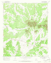
~ Red Flats NM topo map, 1:24000 scale, 7.5 X 7.5 Minute, Historical, 1967, updated 1971
Red Flats, New Mexico, USGS topographic map dated 1967.
Includes geographic coordinates (latitude and longitude). This topographic map is suitable for hiking, camping, and exploring, or framing it as a wall map.
Printed on-demand using high resolution imagery, on heavy weight and acid free paper, or alternatively on a variety of synthetic materials.
Topos available on paper, Waterproof, Poly, or Tyvek. Usually shipping rolled, unless combined with other folded maps in one order.
- Product Number: USGS-5383159
- Free digital map download (high-resolution, GeoPDF): Red Flats, New Mexico (file size: 9 MB)
- Map Size: please refer to the dimensions of the GeoPDF map above
- Weight (paper map): ca. 55 grams
- Map Type: POD USGS Topographic Map
- Map Series: HTMC
- Map Verison: Historical
- Cell ID: 37328
- Scan ID: 192046
- Imprint Year: 1971
- Woodland Tint: Yes
- Aerial Photo Year: 1966
- Field Check Year: 1967
- Datum: NAD27
- Map Projection: Polyconic
- Map published by United States Geological Survey
- Map Language: English
- Scanner Resolution: 600 dpi
- Map Cell Name: Red Flats
- Grid size: 7.5 X 7.5 Minute
- Date on map: 1967
- Map Scale: 1:24000
- Geographical region: New Mexico, United States
Neighboring Maps:
All neighboring USGS topo maps are available for sale online at a variety of scales.
Spatial coverage:
Topo map Red Flats, New Mexico, covers the geographical area associated the following places:
- Red Flats - Glasscock Tank - Coyote Tank - North Homestead Tank - Bennett Tank - Red Peak Tank - Sawtooth Tank - Brasier Tank - Clark Tank - Homestead Tank - East Pie Town Tank - Holden Tank - West Sawtooth Well - West Pie Town Tank - Allen Tank - Lone Mountain - McWhorter Tank - Red Peak - West End Tank - Goesling Tank - Fence Line Tank - North Forest Well - Little Tank - Dome Tank - Airplane Hills - Cedar Tank - Hidden Tank - Red Flats Tank - Sunflower Flat - Castle Dome - Capital Dome
- Map Area ID: AREA34.37534.25-108.125-108
- Northwest corner Lat/Long code: USGSNW34.375-108.125
- Northeast corner Lat/Long code: USGSNE34.375-108
- Southwest corner Lat/Long code: USGSSW34.25-108.125
- Southeast corner Lat/Long code: USGSSE34.25-108
- Northern map edge Latitude: 34.375
- Southern map edge Latitude: 34.25
- Western map edge Longitude: -108.125
- Eastern map edge Longitude: -108


