
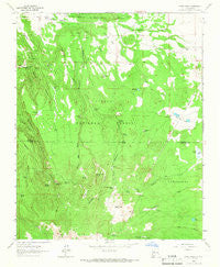
~ Cerro Pelon NM topo map, 1:24000 scale, 7.5 X 7.5 Minute, Historical, 1963, updated 1966
Cerro Pelon, New Mexico, USGS topographic map dated 1963.
Includes geographic coordinates (latitude and longitude). This topographic map is suitable for hiking, camping, and exploring, or framing it as a wall map.
Printed on-demand using high resolution imagery, on heavy weight and acid free paper, or alternatively on a variety of synthetic materials.
Topos available on paper, Waterproof, Poly, or Tyvek. Usually shipping rolled, unless combined with other folded maps in one order.
- Product Number: USGS-5379010
- Free digital map download (high-resolution, GeoPDF): Cerro Pelon, New Mexico (file size: 12 MB)
- Map Size: please refer to the dimensions of the GeoPDF map above
- Weight (paper map): ca. 55 grams
- Map Type: POD USGS Topographic Map
- Map Series: HTMC
- Map Verison: Historical
- Cell ID: 8027
- Scan ID: 190115
- Imprint Year: 1966
- Woodland Tint: Yes
- Aerial Photo Year: 1958
- Field Check Year: 1963
- Datum: NAD27
- Map Projection: Polyconic
- Map published by United States Geological Survey
- Map Language: English
- Scanner Resolution: 600 dpi
- Map Cell Name: Cerro Pelon
- Grid size: 7.5 X 7.5 Minute
- Date on map: 1963
- Map Scale: 1:24000
- Geographical region: New Mexico, United States
Neighboring Maps:
All neighboring USGS topo maps are available for sale online at a variety of scales.
Spatial coverage:
Topo map Cerro Pelon, New Mexico, covers the geographical area associated the following places:
- Llanito Frio Tanks - Spud Patch - Cold Spring Water Well - Effran Tank - San Mateo Spring - Big Lake - Cerro Osha - Maruca Canyon - Lagunita Tank - Corner Spring - Antelope Tank - San Mateo Springs Tract Number Two - Cold Spring - La Cuchilla - Sandoval Spring - Seco Tank - Frog Lake Tank - Salazar Tank - Spud Patch Canyon - CCC Spring - Willow Spring - Fernandez Camp - George Tank - Spruce Tank - San Lucas Spring - American Tank - Ojo Piedra - Colorado Tank - La Cuchilla Pit Mine - Lower American Spring - Laguna Largo - Maruca Spring - Sheep Corral Stock Tank - Cerro Pelon - Manuel Spring - Colorado Spring - Antelope Flats - Big Canyon Spring - Escondido Tank - Elkins Camp - Cerro Venada - Elkins Spring - Gobbler Spring - Upper American Canyon Spring - KLLT-FM (Grants) - American Canyon - La Mosca Lookout Tower - Silt Tank - Salazar Spring
- Map Area ID: AREA35.37535.25-107.625-107.5
- Northwest corner Lat/Long code: USGSNW35.375-107.625
- Northeast corner Lat/Long code: USGSNE35.375-107.5
- Southwest corner Lat/Long code: USGSSW35.25-107.625
- Southeast corner Lat/Long code: USGSSE35.25-107.5
- Northern map edge Latitude: 35.375
- Southern map edge Latitude: 35.25
- Western map edge Longitude: -107.625
- Eastern map edge Longitude: -107.5


