
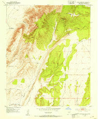
~ Cerro Montoso NM topo map, 1:24000 scale, 7.5 X 7.5 Minute, Historical, 1952, updated 1959
Cerro Montoso, New Mexico, USGS topographic map dated 1952.
Includes geographic coordinates (latitude and longitude). This topographic map is suitable for hiking, camping, and exploring, or framing it as a wall map.
Printed on-demand using high resolution imagery, on heavy weight and acid free paper, or alternatively on a variety of synthetic materials.
Topos available on paper, Waterproof, Poly, or Tyvek. Usually shipping rolled, unless combined with other folded maps in one order.
- Product Number: USGS-5378998
- Free digital map download (high-resolution, GeoPDF): Cerro Montoso, New Mexico (file size: 12 MB)
- Map Size: please refer to the dimensions of the GeoPDF map above
- Weight (paper map): ca. 55 grams
- Map Type: POD USGS Topographic Map
- Map Series: HTMC
- Map Verison: Historical
- Cell ID: 8024
- Scan ID: 190111
- Imprint Year: 1959
- Woodland Tint: Yes
- Aerial Photo Year: 1951
- Field Check Year: 1952
- Datum: NAD27
- Map Projection: Polyconic
- Map published by United States Geological Survey
- Map Language: English
- Scanner Resolution: 600 dpi
- Map Cell Name: Cerro Montoso
- Grid size: 7.5 X 7.5 Minute
- Date on map: 1952
- Map Scale: 1:24000
- Geographical region: New Mexico, United States
Neighboring Maps:
All neighboring USGS topo maps are available for sale online at a variety of scales.
Spatial coverage:
Topo map Cerro Montoso, New Mexico, covers the geographical area associated the following places:
- Montosa Draw - Aqua Tores Water Well - Parker Water Well - Cerro Montoso - Tom Wright Mill - Grey Ridge - Parker Ranch - Upper Montosa Well - Lower Montosa Well - Sepultura Flat - John Renlods Tank - Agua de los Torres Mill - Patterson Tank - Los Pinos Mountains - Test Water Well 2 - Cerro Pelon - Burris HQ Water Well - Tecolote Draw - Red Mesa - Conqueror Mine - Burris and Nunn Ranch
- Map Area ID: AREA34.37534.25-106.625-106.5
- Northwest corner Lat/Long code: USGSNW34.375-106.625
- Northeast corner Lat/Long code: USGSNE34.375-106.5
- Southwest corner Lat/Long code: USGSSW34.25-106.625
- Southeast corner Lat/Long code: USGSSE34.25-106.5
- Northern map edge Latitude: 34.375
- Southern map edge Latitude: 34.25
- Western map edge Longitude: -106.625
- Eastern map edge Longitude: -106.5


