
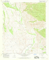
~ Canteen Canyon NM topo map, 1:24000 scale, 7.5 X 7.5 Minute, Historical, 1965, updated 1970
Canteen Canyon, New Mexico, USGS topographic map dated 1965.
Includes geographic coordinates (latitude and longitude). This topographic map is suitable for hiking, camping, and exploring, or framing it as a wall map.
Printed on-demand using high resolution imagery, on heavy weight and acid free paper, or alternatively on a variety of synthetic materials.
Topos available on paper, Waterproof, Poly, or Tyvek. Usually shipping rolled, unless combined with other folded maps in one order.
- Product Number: USGS-5378776
- Free digital map download (high-resolution, GeoPDF): Canteen Canyon, New Mexico (file size: 11 MB)
- Map Size: please refer to the dimensions of the GeoPDF map above
- Weight (paper map): ca. 55 grams
- Map Type: POD USGS Topographic Map
- Map Series: HTMC
- Map Verison: Historical
- Cell ID: 7101
- Scan ID: 189977
- Imprint Year: 1970
- Woodland Tint: Yes
- Aerial Photo Year: 1964
- Field Check Year: 1965
- Datum: NAD27
- Map Projection: Polyconic
- Map published by United States Geological Survey
- Map Language: English
- Scanner Resolution: 600 dpi
- Map Cell Name: Canteen Canyon
- Grid size: 7.5 X 7.5 Minute
- Date on map: 1965
- Map Scale: 1:24000
- Geographical region: New Mexico, United States
Neighboring Maps:
All neighboring USGS topo maps are available for sale online at a variety of scales.
Spatial coverage:
Topo map Canteen Canyon, New Mexico, covers the geographical area associated the following places:
- Nine Hundred Sixteen Ranch - Maldonado Canyon - Victoria Mine - Fall Canyon - Canteen Canyon - Upper Gila Site Number Nine Dam - Mogollon Creek - Brushy Canyon - Clark Canyon Dam - Miller Canyon - Indian Canyon - Upper Gila Site Number Seven Dam - Upper Gila Site Number Six Dam - Watson Mountain - Rough Canyon - Spar Canyon - Cedar Hill Prospect - Cherry Spring - Brock Canyon - Upper Gila Site Number Eight Dam - Juniper Spring - Guerrero Canyon - Upper Gila Site Number 11 Dam - Davis Canyon - Wild Horse Mesa - Upper Gila Site Number 10 Dam - Maldonado Cemetery - Doyle Canyon
- Map Area ID: AREA33.12533-108.625-108.5
- Northwest corner Lat/Long code: USGSNW33.125-108.625
- Northeast corner Lat/Long code: USGSNE33.125-108.5
- Southwest corner Lat/Long code: USGSSW33-108.625
- Southeast corner Lat/Long code: USGSSE33-108.5
- Northern map edge Latitude: 33.125
- Southern map edge Latitude: 33
- Western map edge Longitude: -108.625
- Eastern map edge Longitude: -108.5


