
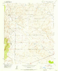
~ Canoncito School NM topo map, 1:24000 scale, 7.5 X 7.5 Minute, Historical, 1954, updated 1955
Canoncito School, New Mexico, USGS topographic map dated 1954.
Includes geographic coordinates (latitude and longitude). This topographic map is suitable for hiking, camping, and exploring, or framing it as a wall map.
Printed on-demand using high resolution imagery, on heavy weight and acid free paper, or alternatively on a variety of synthetic materials.
Topos available on paper, Waterproof, Poly, or Tyvek. Usually shipping rolled, unless combined with other folded maps in one order.
- Product Number: USGS-5378758
- Free digital map download (high-resolution, GeoPDF): Canoncito School, New Mexico (file size: 9 MB)
- Map Size: please refer to the dimensions of the GeoPDF map above
- Weight (paper map): ca. 55 grams
- Map Type: POD USGS Topographic Map
- Map Series: HTMC
- Map Verison: Historical
- Cell ID: 7093
- Scan ID: 189970
- Imprint Year: 1955
- Woodland Tint: Yes
- Aerial Photo Year: 1951
- Field Check Year: 1954
- Datum: NAD27
- Map Projection: Polyconic
- Map published by United States Geological Survey
- Map Language: English
- Scanner Resolution: 600 dpi
- Map Cell Name: Canoncito School
- Grid size: 7.5 X 7.5 Minute
- Date on map: 1954
- Map Scale: 1:24000
- Geographical region: New Mexico, United States
Neighboring Maps:
All neighboring USGS topo maps are available for sale online at a variety of scales.
Spatial coverage:
Topo map Canoncito School, New Mexico, covers the geographical area associated the following places:
- RWP7 Water Well - RWP14 Water Well - Navajo Nation Emergency Medical Services Tohajiilee - RWP8 Water Well - Cañada los Alamos - RT-7 Water Well - Cañoncito Reservation (historical) - Ferro Mine - City of Albuquerque West Mesa Well - Cañoncito Navajo Day School - Sandoval Canyon - Cañoncito Chapter - Desid Plat Water Well - Desid Plat Water Well - PD and C 5 Water Well - Cañoncito Mine - Rio Salado North Detention Dam Number 46 - RWP4 Water Well - Herrera Ranch
- Map Area ID: AREA35.12535-107.125-107
- Northwest corner Lat/Long code: USGSNW35.125-107.125
- Northeast corner Lat/Long code: USGSNE35.125-107
- Southwest corner Lat/Long code: USGSSW35-107.125
- Southeast corner Lat/Long code: USGSSE35-107
- Northern map edge Latitude: 35.125
- Southern map edge Latitude: 35
- Western map edge Longitude: -107.125
- Eastern map edge Longitude: -107


