
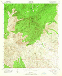
~ Burro Peak NM topo map, 1:24000 scale, 7.5 X 7.5 Minute, Historical, 1950, updated 1967
Burro Peak, New Mexico, USGS topographic map dated 1950.
Includes geographic coordinates (latitude and longitude). This topographic map is suitable for hiking, camping, and exploring, or framing it as a wall map.
Printed on-demand using high resolution imagery, on heavy weight and acid free paper, or alternatively on a variety of synthetic materials.
Topos available on paper, Waterproof, Poly, or Tyvek. Usually shipping rolled, unless combined with other folded maps in one order.
- Product Number: USGS-5378600
- Free digital map download (high-resolution, GeoPDF): Burro Peak, New Mexico (file size: 16 MB)
- Map Size: please refer to the dimensions of the GeoPDF map above
- Weight (paper map): ca. 55 grams
- Map Type: POD USGS Topographic Map
- Map Series: HTMC
- Map Verison: Historical
- Cell ID: 6392
- Scan ID: 189913
- Imprint Year: 1967
- Woodland Tint: Yes
- Aerial Photo Year: 1945
- Field Check Year: 1950
- Datum: NAD27
- Map Projection: Polyconic
- Map published by United States Army Corps of Engineers
- Map Language: English
- Scanner Resolution: 600 dpi
- Map Cell Name: Burro Peak
- Grid size: 7.5 X 7.5 Minute
- Date on map: 1950
- Map Scale: 1:24000
- Geographical region: New Mexico, United States
Neighboring Maps:
All neighboring USGS topo maps are available for sale online at a variety of scales.
Spatial coverage:
Topo map Burro Peak, New Mexico, covers the geographical area associated the following places:
- Silver Dollar Mine - Tank Number One - Merry Widow Shaft - Hop Williams Mine - Knight Canyon Tank - Mud Spring - Gold Gulch Placer - Sprouse Mine - Sawmill Canyon - Walking X Ranch - Gold Gulch Spring - Thompson Windmill - Copeland Tank - Grapevine Spring - Shrine - McCauley Ranch - Rustler Canyon - Neglected Mine - Copeland Mine - Walnut Creek Windmill - Wild Irishman Number 5 Shafts - Arrastre Windmill - Uncle Jimmy Thwaits Mine - John Malone Shaft - S Big Burro Mountains Euxenite Deposit - Red Hill - Gold Gulch Windmill - Russel Ranch - Spar Hill Mine - Jacks Peak - Pine Canyon Windmill - Austin Amazon Mines - Indian Hill - KXKK-FM (Lordsburg) - Summit Deposit - Ferguson Mountain - Rustler Spring - Thompson Canyon Windmill - Red Hill Turquoise Mine - Merry Widow Mine - Burro Peak - Silver Dollar Mine - 00988 Water Well - Deadman Canyon Shafts and Prospect - Silsby Ranch - 00989 Water Well - Burro Mountain Homestead - Sunset Gold Field - Floyd Collins Mine - Goat Camp Windmill - Section Fifteen Windmill
- Map Area ID: AREA32.62532.5-108.5-108.375
- Northwest corner Lat/Long code: USGSNW32.625-108.5
- Northeast corner Lat/Long code: USGSNE32.625-108.375
- Southwest corner Lat/Long code: USGSSW32.5-108.5
- Southeast corner Lat/Long code: USGSSE32.5-108.375
- Northern map edge Latitude: 32.625
- Southern map edge Latitude: 32.5
- Western map edge Longitude: -108.5
- Eastern map edge Longitude: -108.375


