
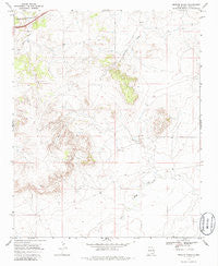
~ Briscoe Ranch NM topo map, 1:24000 scale, 7.5 X 7.5 Minute, Historical, 1968, updated 1986
Briscoe Ranch, New Mexico, USGS topographic map dated 1968.
Includes geographic coordinates (latitude and longitude). This topographic map is suitable for hiking, camping, and exploring, or framing it as a wall map.
Printed on-demand using high resolution imagery, on heavy weight and acid free paper, or alternatively on a variety of synthetic materials.
Topos available on paper, Waterproof, Poly, or Tyvek. Usually shipping rolled, unless combined with other folded maps in one order.
- Product Number: USGS-5378496
- Free digital map download (high-resolution, GeoPDF): Briscoe Ranch, New Mexico (file size: 9 MB)
- Map Size: please refer to the dimensions of the GeoPDF map above
- Weight (paper map): ca. 55 grams
- Map Type: POD USGS Topographic Map
- Map Series: HTMC
- Map Verison: Historical
- Cell ID: 5494
- Scan ID: 193846
- Imprint Year: 1986
- Woodland Tint: Yes
- Aerial Photo Year: 1967
- Field Check Year: 1968
- Datum: NAD27
- Map Projection: Polyconic
- Map published by United States Geological Survey
- Map Language: English
- Scanner Resolution: 600 dpi
- Map Cell Name: Briscoe Ranch
- Grid size: 7.5 X 7.5 Minute
- Date on map: 1968
- Map Scale: 1:24000
- Geographical region: New Mexico, United States
Neighboring Maps:
All neighboring USGS topo maps are available for sale online at a variety of scales.
Spatial coverage:
Topo map Briscoe Ranch, New Mexico, covers the geographical area associated the following places:
- 05104 Water Well - 05127 Water Well - 10096 Water Well - 05132 Water Well - 05126 Water Well - 05091 Water Well - 05128 Water Well - 05090 Water Well - Tucumcari Division - 05124 Water Well - 05093 Water Well - Paris Creek - 05120 Water Well - 10104 Water Well - 10100 Water Well - Jose - 10103 Water Well - 05130 Water Well - 05118 Water Well - Mesa Quemado - Briscoe Ranch - 05105 Water Well - 05099 Water Well - 05103 Water Well - Kilgore - 05092 Water Well - 05110 Water Well
- Map Area ID: AREA35.12535-103.875-103.75
- Northwest corner Lat/Long code: USGSNW35.125-103.875
- Northeast corner Lat/Long code: USGSNE35.125-103.75
- Southwest corner Lat/Long code: USGSSW35-103.875
- Southeast corner Lat/Long code: USGSSE35-103.75
- Northern map edge Latitude: 35.125
- Southern map edge Latitude: 35
- Western map edge Longitude: -103.875
- Eastern map edge Longitude: -103.75


