
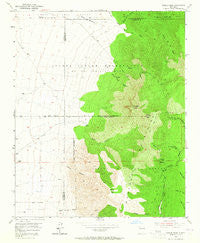
~ Bosque Peak NM topo map, 1:24000 scale, 7.5 X 7.5 Minute, Historical, 1954, updated 1965
Bosque Peak, New Mexico, USGS topographic map dated 1954.
Includes geographic coordinates (latitude and longitude). This topographic map is suitable for hiking, camping, and exploring, or framing it as a wall map.
Printed on-demand using high resolution imagery, on heavy weight and acid free paper, or alternatively on a variety of synthetic materials.
Topos available on paper, Waterproof, Poly, or Tyvek. Usually shipping rolled, unless combined with other folded maps in one order.
- Product Number: USGS-5378450
- Free digital map download (high-resolution, GeoPDF): Bosque Peak, New Mexico (file size: 11 MB)
- Map Size: please refer to the dimensions of the GeoPDF map above
- Weight (paper map): ca. 55 grams
- Map Type: POD USGS Topographic Map
- Map Series: HTMC
- Map Verison: Historical
- Cell ID: 4922
- Scan ID: 189843
- Imprint Year: 1965
- Woodland Tint: Yes
- Aerial Photo Year: 1951
- Field Check Year: 1954
- Datum: NAD27
- Map Projection: Polyconic
- Map published by United States Geological Survey
- Map Language: English
- Scanner Resolution: 600 dpi
- Map Cell Name: Bosque Peak
- Grid size: 7.5 X 7.5 Minute
- Date on map: 1954
- Map Scale: 1:24000
- Geographical region: New Mexico, United States
Neighboring Maps:
All neighboring USGS topo maps are available for sale online at a variety of scales.
Spatial coverage:
Topo map Bosque Peak, New Mexico, covers the geographical area associated the following places:
- Ojito Canyon - Cerro Blanco Trail - Bosque Trail - White Rock Spring - Fourth of July Spring - Diablo Canyon - Pitch Spring - Escondido Spring - Vigil Trail - Lower Encino Spring - Guadalupe Peak - Cañon de los Moyos - Cerro Blanco - Garcia Canyon - Piedra Lisa Spring - North Bosque Peak - 10029 Water Well - Garcia Spring - Yellowstone Trail - Tilio Spring - Albuquerque Trail - Bosque Trailhead - Bosque Peak - Fourth of July Campground - Lolito Spring - Ojito Trail - 10241 Water Well - Diablo Spring - Mosca Trail - Big Spring - Upper Encino Spring - Bosque Peak Cemetery - Encino Canyon - Los Vayas Spring - Cerro Blanco Trailhead - Ojito Los Burros Spring - Lo De Padilla - Canon de los Seis - Cave Spring - Sand Canyon - Yellowstone Spring - Albuquerque Trail Spring - Upper Fourth of July Spring - Mosca Peak - White Rock Canyon
- Map Area ID: AREA34.87534.75-106.5-106.375
- Northwest corner Lat/Long code: USGSNW34.875-106.5
- Northeast corner Lat/Long code: USGSNE34.875-106.375
- Southwest corner Lat/Long code: USGSSW34.75-106.5
- Southeast corner Lat/Long code: USGSSE34.75-106.375
- Northern map edge Latitude: 34.875
- Southern map edge Latitude: 34.75
- Western map edge Longitude: -106.5
- Eastern map edge Longitude: -106.375


