
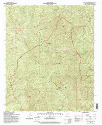
~ Blue Mountain NM topo map, 1:24000 scale, 7.5 X 7.5 Minute, Historical, 1995, updated 1998
Blue Mountain, New Mexico, USGS topographic map dated 1995.
Includes geographic coordinates (latitude and longitude). This topographic map is suitable for hiking, camping, and exploring, or framing it as a wall map.
Printed on-demand using high resolution imagery, on heavy weight and acid free paper, or alternatively on a variety of synthetic materials.
Topos available on paper, Waterproof, Poly, or Tyvek. Usually shipping rolled, unless combined with other folded maps in one order.
- Product Number: USGS-5378410
- Free digital map download (high-resolution, GeoPDF): Blue Mountain, New Mexico (file size: 18 MB)
- Map Size: please refer to the dimensions of the GeoPDF map above
- Weight (paper map): ca. 55 grams
- Map Type: POD USGS Topographic Map
- Map Series: HTMC
- Map Verison: Historical
- Cell ID: 4534
- Scan ID: 193829
- Imprint Year: 1998
- Woodland Tint: Yes
- Aerial Photo Year: 1992
- Field Check Year: 1995
- Survey Year: 1995
- Datum: NAD27
- Map Projection: Transverse Mercator
- Map published by United States Forest Service
- Map Language: English
- Scanner Resolution: 600 dpi
- Map Cell Name: Blue Mountain
- Grid size: 7.5 X 7.5 Minute
- Date on map: 1995
- Map Scale: 1:24000
- Geographical region: New Mexico, United States
Neighboring Maps:
All neighboring USGS topo maps are available for sale online at a variety of scales.
Spatial coverage:
Topo map Blue Mountain, New Mexico, covers the geographical area associated the following places:
- San Mateo Mountains - Cow Trap Spring - Cave Peaks - Twentyfive Yard Spring - Yellow Jacket Canyon - Hardscrabble Spring - Cold Spring - Pothole Spring - Old Hidden Spring - East Red Well - Water Canyon - Skeleton Ridge - Coffee Pot Canyon - West Fork Cold Spring Canyon - Blue Mountain - Turkey Springs - Drift Fence Canyon - Indian Creek - Hidden Springs Canyon - Apache Kid Peak - Allen Spring Canyon - Magdalena Ranger District - Drift Fence Well - Tool Box Spring - Cyclone Saddle - Bull Saddle - Apache Kid Grave Site - Black Mountain - Milligan Peak - Holdup Mountain - West Blue Mountain - Indian Spring - Teepee Peak - Cub Spring - Apache Kid Wilderness - Alexander Spring - Bull Springs - Hidden Spring - Bull Canyon
- Map Area ID: AREA33.7533.625-107.5-107.375
- Northwest corner Lat/Long code: USGSNW33.75-107.5
- Northeast corner Lat/Long code: USGSNE33.75-107.375
- Southwest corner Lat/Long code: USGSSW33.625-107.5
- Southeast corner Lat/Long code: USGSSE33.625-107.375
- Northern map edge Latitude: 33.75
- Southern map edge Latitude: 33.625
- Western map edge Longitude: -107.5
- Eastern map edge Longitude: -107.375


