
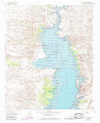
~ Black Bluffs NM topo map, 1:24000 scale, 7.5 X 7.5 Minute, Historical, 1961, updated 1985
Black Bluffs, New Mexico, USGS topographic map dated 1961.
Includes geographic coordinates (latitude and longitude). This topographic map is suitable for hiking, camping, and exploring, or framing it as a wall map.
Printed on-demand using high resolution imagery, on heavy weight and acid free paper, or alternatively on a variety of synthetic materials.
Topos available on paper, Waterproof, Poly, or Tyvek. Usually shipping rolled, unless combined with other folded maps in one order.
- Product Number: USGS-5378330
- Free digital map download (high-resolution, GeoPDF): Black Bluffs, New Mexico (file size: 15 MB)
- Map Size: please refer to the dimensions of the GeoPDF map above
- Weight (paper map): ca. 55 grams
- Map Type: POD USGS Topographic Map
- Map Series: HTMC
- Map Verison: Historical
- Cell ID: 4077
- Scan ID: 193811
- Imprint Year: 1985
- Woodland Tint: Yes
- Visual Version Number: 1
- Photo Revision Year: 1980
- Aerial Photo Year: 1978
- Edit Year: 1980
- Datum: NAD27
- Map Projection: Polyconic
- Map published by United States Geological Survey
- Map Language: English
- Scanner Resolution: 600 dpi
- Map Cell Name: Black Bluffs
- Grid size: 7.5 X 7.5 Minute
- Date on map: 1961
- Map Scale: 1:24000
- Geographical region: New Mexico, United States
Neighboring Maps:
All neighboring USGS topo maps are available for sale online at a variety of scales.
Spatial coverage:
Topo map Black Bluffs, New Mexico, covers the geographical area associated the following places:
- Red Cliff - Walnut Canyon - Pinosa Canyon - Alamosa Creek - Blander Reservoir Number One - Monticello Canyon - Bolander - North Monticello Point - White Cliffs - Elkins Ranch - Narrows Water Well - Cottonwood Canyon - Three Sisters Point - RG 4091 Water Well - Mitchell Canyon - Crater Hill - Black Bluffs - Double Canyon - Hackberry Canyon - South Monticello Point - Mitchell Point - Reynolds Canyon - Chavez Windmill - RG 6977 Water Well - Alamosa Ranch House and Blacksmith Shop Historic Site - Engle Point - Flying Eagle Canyon - Hellion Canyon
- Map Area ID: AREA33.37533.25-107.25-107.125
- Northwest corner Lat/Long code: USGSNW33.375-107.25
- Northeast corner Lat/Long code: USGSNE33.375-107.125
- Southwest corner Lat/Long code: USGSSW33.25-107.25
- Southeast corner Lat/Long code: USGSSE33.25-107.125
- Northern map edge Latitude: 33.375
- Southern map edge Latitude: 33.25
- Western map edge Longitude: -107.25
- Eastern map edge Longitude: -107.125


