
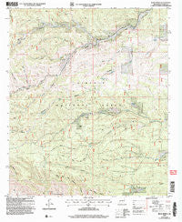
~ Bear Spring NM topo map, 1:24000 scale, 7.5 X 7.5 Minute, Historical, 2004, updated 2006
Bear Spring, New Mexico, USGS topographic map dated 2004.
Includes geographic coordinates (latitude and longitude). This topographic map is suitable for hiking, camping, and exploring, or framing it as a wall map.
Printed on-demand using high resolution imagery, on heavy weight and acid free paper, or alternatively on a variety of synthetic materials.
Topos available on paper, Waterproof, Poly, or Tyvek. Usually shipping rolled, unless combined with other folded maps in one order.
- Product Number: USGS-5378176
- Free digital map download (high-resolution, GeoPDF): Bear Spring, New Mexico (file size: 14 MB)
- Map Size: please refer to the dimensions of the GeoPDF map above
- Weight (paper map): ca. 55 grams
- Map Type: POD USGS Topographic Map
- Map Series: HTMC
- Map Verison: Historical
- Cell ID: 2850
- Scan ID: 193788
- Imprint Year: 2006
- Woodland Tint: Yes
- Aerial Photo Year: 1999
- Edit Year: 2004
- Datum: NAD83
- Map Projection: Universal Transverse Mercator
- Map published by United States Forest Service
- Map Language: English
- Scanner Resolution: 600 dpi
- Map Cell Name: Bear Spring
- Grid size: 7.5 X 7.5 Minute
- Date on map: 2004
- Map Scale: 1:24000
- Geographical region: New Mexico, United States
Neighboring Maps:
All neighboring USGS topo maps are available for sale online at a variety of scales.
Spatial coverage:
Topo map Bear Spring, New Mexico, covers the geographical area associated the following places:
- Hughes Canyon - Upper Long Tank - Board Canyon - Long Canyon - Jeffers Spring - McEwan Spring - Jim Lewis Canyon - Carrisa Lookout Complex Historic Site - Lick Tank - Welch Lodge - Cecil Smith Water - Gage Canyon - Salt Rock Canyon - Long Canyon - Lick Ridge - Jeffers Cemetery - Pickett Canyon - Bear Spring - Lick Trick Tank - Buck Canyon - Trail Canyon - Carrisa Lookout Tower - Sleepy Grass Canyon
- Map Area ID: AREA32.7532.625-105.625-105.5
- Northwest corner Lat/Long code: USGSNW32.75-105.625
- Northeast corner Lat/Long code: USGSNE32.75-105.5
- Southwest corner Lat/Long code: USGSSW32.625-105.625
- Southeast corner Lat/Long code: USGSSE32.625-105.5
- Northern map edge Latitude: 32.75
- Southern map edge Latitude: 32.625
- Western map edge Longitude: -105.625
- Eastern map edge Longitude: -105.5


