
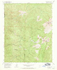
~ Aspen Basin NM topo map, 1:24000 scale, 7.5 X 7.5 Minute, Historical, 1953, updated 1971
Aspen Basin, New Mexico, USGS topographic map dated 1953.
Includes geographic coordinates (latitude and longitude). This topographic map is suitable for hiking, camping, and exploring, or framing it as a wall map.
Printed on-demand using high resolution imagery, on heavy weight and acid free paper, or alternatively on a variety of synthetic materials.
Topos available on paper, Waterproof, Poly, or Tyvek. Usually shipping rolled, unless combined with other folded maps in one order.
- Product Number: USGS-5378068
- Free digital map download (high-resolution, GeoPDF): Aspen Basin, New Mexico (file size: 14 MB)
- Map Size: please refer to the dimensions of the GeoPDF map above
- Weight (paper map): ca. 55 grams
- Map Type: POD USGS Topographic Map
- Map Series: HTMC
- Map Verison: Historical
- Cell ID: 1709
- Scan ID: 189652
- Imprint Year: 1971
- Woodland Tint: Yes
- Aerial Photo Year: 1948
- Field Check Year: 1953
- Datum: NAD27
- Map Projection: Polyconic
- Map published by United States Geological Survey
- Map Language: English
- Scanner Resolution: 600 dpi
- Map Cell Name: Aspen Basin
- Grid size: 7.5 X 7.5 Minute
- Date on map: 1953
- Map Scale: 1:24000
- Geographical region: New Mexico, United States
Neighboring Maps:
All neighboring USGS topo maps are available for sale online at a variety of scales.
Spatial coverage:
Topo map Aspen Basin, New Mexico, covers the geographical area associated the following places:
- Bear Wallow Trail - Aspen Peak - Molly Hogan Ski Trail - Burro Alley Ski Trail - Puerto Nambe - Aspen Vista Picnic Area - Upper Midland Ski Trail - Gayway Ski Trail - Camp Robber Ski Trail - Alpine Ski Trail - Lower Broadway Ski Trail - Rio Capulin - Upper Broadway Ski Trail - Santa Fe Trail Ski Trail - Desafio Ski Trail - Aspen Ranch - Davey Lane Ski Trail - Easter Bowl Ski Trail - Norski Cross Country Ski Track - North Fork Tesuque Creek - Santa Fe Lake - Tequila Sunrise Ski Trail - Winsor Trail - Lower Burro Ski Trail - Aspen Basin - Big Tesuque Trail - Muerte Ski Trail - Columbine Ski Trail - Cañada Vaca - Borrego Trail - Snows Ski Trail - Santa Fe Baldy - Sierra Lodge - Azmataz Ski Trail - Penitente Peak - Rio en Medio Trail - Avalanche Bowl Ski Trail - Chipmunk Corner Ski Trail - Aspen Basin Recreation Area - Thunderbird Ski Trail - Rio Nambe Trail - Easy Street Ski Trail - Open Slope Ski Trail - Pope Ski Trail - Aspen Cabin - Marmot Ski Trail - Nambe Lake - South Fork Tesuque Creek - Thru Way Ski Trail - Sunset Ski Trail - Desperado Ski Trail - Rancho Viejo - Parachute Ski Trail - Roadrunner Ski Trail - First Traks Ski Trail - Spruce Bowl Ski Trail - Big Tesuque Campground - Pipeline Ski Trail - Slalom Slope Ski Trail - Santa Fe Ski Basin - Lower Midland Ski Trail - Cornice Ski Trail - Lake Katherine - JC Ski Trail - Bozo Ski Trail - Lake Peak - Santa Fe Recreation Area - Wizard Ski Trail - Aspen Forrest Service Station - Sunnyside Ski Trail - Juan de Gabaldon Grant - Double Eagle V Ski Trail - Tesuque Peak
- Map Area ID: AREA35.87535.75-105.875-105.75
- Northwest corner Lat/Long code: USGSNW35.875-105.875
- Northeast corner Lat/Long code: USGSNE35.875-105.75
- Southwest corner Lat/Long code: USGSSW35.75-105.875
- Southeast corner Lat/Long code: USGSSE35.75-105.75
- Northern map edge Latitude: 35.875
- Southern map edge Latitude: 35.75
- Western map edge Longitude: -105.875
- Eastern map edge Longitude: -105.75


