
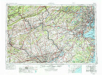
~ Newark NJ topo map, 1:250000 scale, 1 X 2 Degree, Historical, 1944, updated 1974
Newark, New Jersey, USGS topographic map dated 1944.
Includes geographic coordinates (latitude and longitude). This topographic map is suitable for hiking, camping, and exploring, or framing it as a wall map.
Printed on-demand using high resolution imagery, on heavy weight and acid free paper, or alternatively on a variety of synthetic materials.
Topos available on paper, Waterproof, Poly, or Tyvek. Usually shipping rolled, unless combined with other folded maps in one order.
- Product Number: USGS-5377650
- Free digital map download (high-resolution, GeoPDF): Newark, New Jersey (file size: 26 MB)
- Map Size: please refer to the dimensions of the GeoPDF map above
- Weight (paper map): ca. 55 grams
- Map Type: POD USGS Topographic Map
- Map Series: HTMC
- Map Verison: Historical
- Cell ID: 68933
- Scan ID: 255460
- Imprint Year: 1974
- Woodland Tint: Yes
- Photo Revision Year: 1969
- Aerial Photo Year: 1944
- Edit Year: 1969
- Datum: Unstated
- Map Projection: Transverse Mercator
- Map published by United States Geological Survey
- Map Language: English
- Scanner Resolution: 600 dpi
- Map Cell Name: Newark
- Grid size: 1 X 2 Degree
- Date on map: 1944
- Map Scale: 1:250000
- Geographical region: New Jersey, United States
Neighboring Maps:
All neighboring USGS topo maps are available for sale online at a variety of scales.
Spatial coverage:
Topo map Newark, New Jersey, covers the geographical area associated the following places:
- Union Square - Bath Addition - Chestnut Hill - Riverton - Wooded Glen - Mantz - Klines Corner - Hartzells Ferry - Phalanx - Silverton Estates - Southwind Mobile Home Park - Pickering - Peapack - Calmensin - Holmdel - Rahns - Warrenville - Hampton Junction - Hopewell - Hampton - Red Mill - Shinnecock - Prospect Park - Green Grove - Pages Corner - Rosewood Park - Hanover - Dresher - Hillside - Sunny Brook Estates - Coventry Terrace Mobile Home Park - Newkirk - Centreville - Emmaus - Glen Alpin - Clearbrook - Califon - Heather Knoll - Bramble Gate - Valley Ridge Farms - Macungie - Collegeville Greene - Golf View Manor - Mount Fern - Keelersville - Odenweldertown - Spring Mill - Madison Hill - Upsal - Bensalem - Saint Vladimirs - Fiddletown - Cobbs Corner - Bally - Reliance - Claussville - Mandalay - Fairmount - Pelham Green - Powder Valley - Meadows at Lower Gwynedd - Lexington Farms - Leisure Village - Reeceville - Greendell - Sharon - Eldridge Park - Marshfield Station - Slatington - Redington - Belvidere - Maiden Creek Estates - Maple Meade - Andorra Springs - Muirfield - Cetronia - Pine Forge - Robert Bruce - Farm School - Mayfair - Atlantic Highlands - Bucktown - Oley Furnace - Gulph Mills Village - Narvon - Walnut Farms - Peters Corner - Hanover Neck - Baederwood - Middletown - Dietrichtown - Milltown - Little Farm Trace Park - Hawktown - Bells Crossing - Alleghenyville - Prospect Plains - Rosemore Gardens - South Mantoloking Beach - Ryans Corner
- Map Area ID: AREA4140-76-74
- Northwest corner Lat/Long code: USGSNW41-76
- Northeast corner Lat/Long code: USGSNE41-74
- Southwest corner Lat/Long code: USGSSW40-76
- Southeast corner Lat/Long code: USGSSE40-74
- Northern map edge Latitude: 41
- Southern map edge Latitude: 40
- Western map edge Longitude: -76
- Eastern map edge Longitude: -74


