
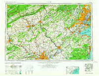
~ Newark NJ topo map, 1:250000 scale, 1 X 2 Degree, Historical, 1964
Newark, New Jersey, USGS topographic map dated 1964.
Includes geographic coordinates (latitude and longitude). This topographic map is suitable for hiking, camping, and exploring, or framing it as a wall map.
Printed on-demand using high resolution imagery, on heavy weight and acid free paper, or alternatively on a variety of synthetic materials.
Topos available on paper, Waterproof, Poly, or Tyvek. Usually shipping rolled, unless combined with other folded maps in one order.
- Product Number: USGS-5377646
- Free digital map download (high-resolution, GeoPDF): Newark, New Jersey (file size: 21 MB)
- Map Size: please refer to the dimensions of the GeoPDF map above
- Weight (paper map): ca. 55 grams
- Map Type: POD USGS Topographic Map
- Map Series: HTMC
- Map Verison: Historical
- Cell ID: 68933
- Scan ID: 255458
- Woodland Tint: Yes
- Aerial Photo Year: 1944
- Datum: Unstated
- Map Projection: Transverse Mercator
- Map published by United States Geological Survey
- Map Language: English
- Scanner Resolution: 600 dpi
- Map Cell Name: Newark
- Grid size: 1 X 2 Degree
- Date on map: 1964
- Map Scale: 1:250000
- Geographical region: New Jersey, United States
Neighboring Maps:
All neighboring USGS topo maps are available for sale online at a variety of scales.
Spatial coverage:
Topo map Newark, New Jersey, covers the geographical area associated the following places:
- Woodlawn - Paulina - Ancient Oaks - Kepner - Keyport - North Princeton - Washington Park - Carpenter - Penn Weldy - Glen Oley Farms - Naughright - Bustleton - Hill Crest - Somerville - Pelham Green - Middlesex - Woodlane - Harbor Terrace - Whitewood - Flemington Junction - Bear Tavern - Somerton Forge - New Durham - North Branch - A Country Place - Columbus - Milltown - Hopewell - Moselem Springs - Pennypack Woods - Pierce Heights - Holmdel - Rock Mill - Carpenters Way - Greenfield Manor - Ager Tract - The Highlands - Hill Yard - Mount Airy - Solebury - Harmony - Cheesequake - Sours Mills - Berwyn - East Greenville - South Hackensack - Ringoes - East Freehold - Pilgerts - Merion View - Bellingham Knoll - Keansburg - Sellersville Heights - Brook Valley - Colesville - Laurence Harbor - Valley View Acres - Williams Corner - Beechwood Acres - Pleasant Plains - Valley Forge Trailer Park - Port Providence - Great Kills - Edgewood Park - Irish Meeting House - West Wyomissing - Cobbs Corner - Limeville - Lower Saucon - Bucksville - Oceanic - Roxburg - Milltown - Groveville - McCrea Mills - Jacksonville - Devault - Whitesville - Glenmoore - Penn Oak Manor - Redshaw Corner - Green Village - Mount Pleasant - Devon - Radburn - Salford - Little York - Annandale - Birch Valley - Slatefield - Teaneck - Longswamp - Ironbridge Estates - Emerson - Sugar Hill Farms - Delta Manor - Scarlets Mill - Green Tree Acres - Potters - Pennsburg
- Map Area ID: AREA4140-76-74
- Northwest corner Lat/Long code: USGSNW41-76
- Northeast corner Lat/Long code: USGSNE41-74
- Southwest corner Lat/Long code: USGSSW40-76
- Southeast corner Lat/Long code: USGSSE40-74
- Northern map edge Latitude: 41
- Southern map edge Latitude: 40
- Western map edge Longitude: -76
- Eastern map edge Longitude: -74


