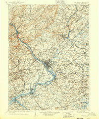
~ Trenton NJ topo map, 1:125000 scale, 30 X 30 Minute, Historical, 1907, updated 1943
Trenton, New Jersey, USGS topographic map dated 1907.
Includes geographic coordinates (latitude and longitude). This topographic map is suitable for hiking, camping, and exploring, or framing it as a wall map.
Printed on-demand using high resolution imagery, on heavy weight and acid free paper, or alternatively on a variety of synthetic materials.
Topos available on paper, Waterproof, Poly, or Tyvek. Usually shipping rolled, unless combined with other folded maps in one order.
- Product Number: USGS-5377634
- Free digital map download (high-resolution, GeoPDF): Trenton, New Jersey (file size: 10 MB)
- Map Size: please refer to the dimensions of the GeoPDF map above
- Weight (paper map): ca. 55 grams
- Map Type: POD USGS Topographic Map
- Map Series: HTMC
- Map Verison: Historical
- Cell ID: 66807
- Scan ID: 255452
- Imprint Year: 1943
- Edit Year: 1905
- Survey Year: 1888
- Datum: NAD
- Map Projection: Polyconic
- Map published by United States Geological Survey
- Map Language: English
- Scanner Resolution: 600 dpi
- Map Cell Name: Trenton
- Grid size: 30 X 30 Minute
- Date on map: 1907
- Map Scale: 1:125000
- Geographical region: New Jersey, United States
Neighboring Maps:
All neighboring USGS topo maps are available for sale online at a variety of scales.
Spatial coverage:
Topo map Trenton, New Jersey, covers the geographical area associated the following places:
- Taylorsville - Cream Ridge - Alexauken - Pennington - Mansfield - Eldridge Park - Polhemustown - Huffnagle - Wrightstown - Hulmeville Terrace - Yellowood - Woodhill - Chewalla Park - Pinewood - Clyde - Mount Rose - Lawrenceville - Bridgetown - Rileyville - Scammells Corner - Blackwells Mills - Borton Landing - Neshaminy Falls - Buckmanville - Lambertville - Deans - Bridgeboro - Bridgetown - Centre Plaza Shopping Center - Skillman - Middlebush - Fallsington - Bristol Terrace Number One - Locust Corner - Cooleys Corner - Hawthorne Park - Thornridge - Kingston - Glenlake - Sunset Hill Garden - Garfield Park - Glendale - Titusville - Tullytown - Fairview - Burlington - Heath Manor - Lawrence - Wallace Mill - Woodlane - Prospect Heights - Center Bridge - Allentown - Newtown - Plainsboro Center - Glenmoore - Penn Valley - Fernwood - Wheat Sheaf - Skin Corner - Idlewood - Reeder - Violet Wood - Franklin Corner - Magnolia Hill - Will O Wood - Delaire Landing - Orchard View - Emilie - Penns Park - Villas of Middletown - Roelofs - Dogwood Hollow - Maple Shade - Yardley - Kendall Park - Creston - Bristol - Snydertown - Andalusia - Edge Hill - Jacksonville - Riverside Park - Wrightstown - Washington Crossing - Bear Tavern - Fairless Hills - West Trenton - Bristol Terrace Number Two - Spring Mill - Centerville - Crestmont Farms - Davisville - Green Curve Heights - Hornerstown - Bustleton - Ewingville - Blue Ridge - Millstone - Midway
- Map Area ID: AREA40.540-75-74.5
- Northwest corner Lat/Long code: USGSNW40.5-75
- Northeast corner Lat/Long code: USGSNE40.5-74.5
- Southwest corner Lat/Long code: USGSSW40-75
- Southeast corner Lat/Long code: USGSSE40-74.5
- Northern map edge Latitude: 40.5
- Southern map edge Latitude: 40
- Western map edge Longitude: -75
- Eastern map edge Longitude: -74.5

