
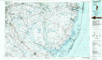
~ Hammonton NJ topo map, 1:100000 scale, 30 X 60 Minute, Historical, 1984, updated 1986
Hammonton, New Jersey, USGS topographic map dated 1984.
Includes geographic coordinates (latitude and longitude). This topographic map is suitable for hiking, camping, and exploring, or framing it as a wall map.
Printed on-demand using high resolution imagery, on heavy weight and acid free paper, or alternatively on a variety of synthetic materials.
Topos available on paper, Waterproof, Poly, or Tyvek. Usually shipping rolled, unless combined with other folded maps in one order.
- Product Number: USGS-5377608
- Free digital map download (high-resolution, GeoPDF): Hammonton, New Jersey (file size: 28 MB)
- Map Size: please refer to the dimensions of the GeoPDF map above
- Weight (paper map): ca. 55 grams
- Map Type: POD USGS Topographic Map
- Map Series: HTMC
- Map Verison: Historical
- Cell ID: 67628
- Scan ID: 255427
- Imprint Year: 1986
- Aerial Photo Year: 1984
- Edit Year: 1984
- Datum: NAD27
- Map Projection: Universal Transverse Mercator
- Planimetric: Yes
- Map published by United States Geological Survey
- Map Language: English
- Scanner Resolution: 600 dpi
- Map Cell Name: Hammonton
- Grid size: 30 X 60 Minute
- Date on map: 1984
- Map Scale: 1:100000
- Geographical region: New Jersey, United States
Neighboring Maps:
All neighboring USGS topo maps are available for sale online at a variety of scales.
Spatial coverage:
Topo map Hammonton, New Jersey, covers the geographical area associated the following places:
- Pipers Corner - Tabernacle - Pine Crest - Bay Side - Blue Bell - Country Lake Estates - Camelot - Maple Shade - Lenola - Nesco - Holgate - Charleston East - Berlin - Pinewood Estates Mobile Home Park - New Freedom - Union Mills - Pestletown - Wescoatville - Kresson - Retreat - Barnard - Howardsville - Harrisville - Winslow Junction - Taunton Lake - Ivystone Farms - Atsion - Forked River - Parkway Manor - Browns Mills - Green Bank - Eagleswood Village - Higbeeville - Batsto - Buena - Kingston Estates - Bamberry Estates - Leektown - Maxwell - Springdale - Butlers Place - Mount - Cranberry Hill - Woodcrest - Germania - Beach Haven Heights - Woodstream - Leisuretowne - Cedar Brook - Lower Bank - Penny Pot - Andrews - Greentree Village - Vincentown - Christopher Mills - Bayside Beach - Fox Chase - Windor Park - Bayville - Wellington Park - Monterey Beach - Rockwood - Louden - Barclay Farm - Four Mile Circle - Deer Chase Manor - Camp Columbus - Fostertown - Martha - Landisville - Crossley (historical) - Cherry Valley - Davenport (historical) - Rosedale - Mystic Island - West Egg Harbor - Willowdale - Windsor Park - McDonald - Speedwell - Clermont - Lanoka Harbor - Bozuretown - Heritage Village - Dicktown - Spraguetown - Lakeview Terrace - Locust Grove - Fox Hollow Woods - Eayrestown - Beaverville - Woodmansie - Bullock - Penbryn - Crowleytown - Springville - Dutchtown - Tansboro - Willow Ridge - Newtonville
- Map Area ID: AREA4039.5-75-74
- Northwest corner Lat/Long code: USGSNW40-75
- Northeast corner Lat/Long code: USGSNE40-74
- Southwest corner Lat/Long code: USGSSW39.5-75
- Southeast corner Lat/Long code: USGSSE39.5-74
- Northern map edge Latitude: 40
- Southern map edge Latitude: 39.5
- Western map edge Longitude: -75
- Eastern map edge Longitude: -74


