
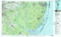
~ Hammonton NJ topo map, 1:100000 scale, 30 X 60 Minute, Historical, 1984, updated 1988
Hammonton, New Jersey, USGS topographic map dated 1984.
Includes geographic coordinates (latitude and longitude). This topographic map is suitable for hiking, camping, and exploring, or framing it as a wall map.
Printed on-demand using high resolution imagery, on heavy weight and acid free paper, or alternatively on a variety of synthetic materials.
Topos available on paper, Waterproof, Poly, or Tyvek. Usually shipping rolled, unless combined with other folded maps in one order.
- Product Number: USGS-5377606
- Free digital map download (high-resolution, GeoPDF): Hammonton, New Jersey (file size: 35 MB)
- Map Size: please refer to the dimensions of the GeoPDF map above
- Weight (paper map): ca. 55 grams
- Map Type: POD USGS Topographic Map
- Map Series: HTMC
- Map Verison: Historical
- Cell ID: 67628
- Scan ID: 255426
- Imprint Year: 1988
- Woodland Tint: Yes
- Aerial Photo Year: 1984
- Edit Year: 1984
- Datum: NAD27
- Map Projection: Universal Transverse Mercator
- Map published by United States Geological Survey
- Map Language: English
- Scanner Resolution: 600 dpi
- Map Cell Name: Hammonton
- Grid size: 30 X 60 Minute
- Date on map: 1984
- Map Scale: 1:100000
- Geographical region: New Jersey, United States
Neighboring Maps:
All neighboring USGS topo maps are available for sale online at a variety of scales.
Spatial coverage:
Topo map Hammonton, New Jersey, covers the geographical area associated the following places:
- Brant Beach - Lenola - Silver Ridge - Ramblewood - Deer Chase Manor - Williamstown - Long Beach - Parkway Manor - Nesco - Cedar Run - Glendale - Beachwood - Pemberton Heights - South Toms River - Glouster Landing - Broad Lane - New Lisbon - Lincoln Park - Hainesport - Kirkwood - Crystal Lake - Wrightsville - New Freedom - Collings Lakes - Island Beach Heights - Woodlawn Estates - Beaverville - Ocean Beach - Mayetta - Marlton Lakes - Waretown - Colestown - Barnegat Pines - Leisuretowne - Rancocas Woods - Ewansville - Woodcrest Acres - Lindenwold - Ivywood - Penny Pot - Oak Shade - Gibbsboro - Berryland - Winslow Junction - Cologne - Rosedale - Springville - West Egg Harbor - Cedar Beach - Sharps Corner - Magnolia - Centerton - Green Bank - Meadford Farms - Stafford Forge - Dover Forge - Forest Grove - Hilltop Estates - Springdale - Woodville - Cherry Downs - Willow Ridge - Murray Grove - Brimfield Crossing - Davenport (historical) - Stanwick - Loveladies - Dellette - Red Lion - North Beach - Forked River - Seaside Heights Harbor - Eayrestown - Speedwell - Germania - Camp Columbus - Bamberry Estates - Dover Beaches North - Eagleswood Village - Lippincotts Corner - River Bank - Victory Lakes - Florence - Overbrook - Alluvium - Fairview - Shinntown - Greenhaven - Presidential Lake Estates - Laurel Harbor - Lucaston - Fairview Estates - Crossley (historical) - West Moorestown - Brighton Beach - Newtonville - Penbryn - Hanover Furnace - Holiday Beach - Parkertown
- Map Area ID: AREA4039.5-75-74
- Northwest corner Lat/Long code: USGSNW40-75
- Northeast corner Lat/Long code: USGSNE40-74
- Southwest corner Lat/Long code: USGSSW39.5-75
- Southeast corner Lat/Long code: USGSSE39.5-74
- Northern map edge Latitude: 40
- Southern map edge Latitude: 39.5
- Western map edge Longitude: -75
- Eastern map edge Longitude: -74


