
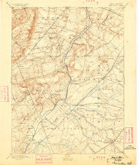
~ Princeton NJ topo map, 1:62500 scale, 15 X 15 Minute, Historical, 1894, updated 1899
Princeton, New Jersey, USGS topographic map dated 1894.
Includes geographic coordinates (latitude and longitude). This topographic map is suitable for hiking, camping, and exploring, or framing it as a wall map.
Printed on-demand using high resolution imagery, on heavy weight and acid free paper, or alternatively on a variety of synthetic materials.
Topos available on paper, Waterproof, Poly, or Tyvek. Usually shipping rolled, unless combined with other folded maps in one order.
- Product Number: USGS-5377494
- Free digital map download (high-resolution, GeoPDF): Princeton, New Jersey (file size: 8 MB)
- Map Size: please refer to the dimensions of the GeoPDF map above
- Weight (paper map): ca. 55 grams
- Map Type: POD USGS Topographic Map
- Map Series: HTMC
- Map Verison: Historical
- Cell ID: 61319
- Scan ID: 255342
- Imprint Year: 1899
- Survey Year: 1885
- Datum: Unstated
- Map Projection: Unstated
- Map published by United States Geological Survey
- Map Language: English
- Scanner Resolution: 600 dpi
- Map Cell Name: Princeton
- Grid size: 15 X 15 Minute
- Date on map: 1894
- Map Scale: 1:62500
- Geographical region: New Jersey, United States
Neighboring Maps:
All neighboring USGS topo maps are available for sale online at a variety of scales.
Spatial coverage:
Topo map Princeton, New Jersey, covers the geographical area associated the following places:
- Rock Mill - Fairview - Black Horse - Sherbrook Estates - Plainsboro - Princessville - Rosedale - Hightstown - Pleasantview - Clarksville - Heathcote - Plainsboro Center - East Trenton Heights - Franklin Park - South Brunswick Terrace - North Princeton - Lawrence - Rockingham - Monmouth Junction - Cedar Grove - Mettler - Griggstown - Eldridge Park - Lawrenceville - Princeton Ivy East - Princeton Meadows - Penns Neck - Hillsborough - Slackwoods - Plainville - Dutchtown - Zion - Cranbury - Deans - Harlingen - Coxs Corner - Middlebush - Kendall Park - Neshanic - Edinburg - Kingston - Old Mill Farms - Sand Hills - Bloomingdale - Princeton Colonial Park - Port Mercer - Quaker Gardens - Pleasant Plains - Blawenburg - Edinburg Park - Ten Mile Run - Hickory Corner - Skillman - Schalks - Princeton Junction - Colonial Lake Lands - Millstone - Little Rocky Hill - Princeton Estates - Sunset Hill Garden - Dayton - Stoutsburg - Golf View Manor - Etra - Post Corner - Sixmile Run - Mount Rose - Grovers Mill - Franklin Corner - Blackwells Mills - Locust Corner - Belle Mead - Millstone - Lewisville - Bakersville - Rocky Hill - Dutch Neck - Sturwood Hamlet - Clyde - Princeton - Bridgepoint
- Map Area ID: AREA40.540.25-74.75-74.5
- Northwest corner Lat/Long code: USGSNW40.5-74.75
- Northeast corner Lat/Long code: USGSNE40.5-74.5
- Southwest corner Lat/Long code: USGSSW40.25-74.75
- Southeast corner Lat/Long code: USGSSE40.25-74.5
- Northern map edge Latitude: 40.5
- Southern map edge Latitude: 40.25
- Western map edge Longitude: -74.75
- Eastern map edge Longitude: -74.5


