
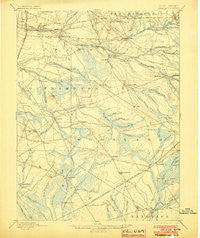
~ Pemberton NJ topo map, 1:62500 scale, 15 X 15 Minute, Historical, 1898, updated 1903
Pemberton, New Jersey, USGS topographic map dated 1898.
Includes geographic coordinates (latitude and longitude). This topographic map is suitable for hiking, camping, and exploring, or framing it as a wall map.
Printed on-demand using high resolution imagery, on heavy weight and acid free paper, or alternatively on a variety of synthetic materials.
Topos available on paper, Waterproof, Poly, or Tyvek. Usually shipping rolled, unless combined with other folded maps in one order.
- Product Number: USGS-5377444
- Free digital map download (high-resolution, GeoPDF): Pemberton, New Jersey (file size: 7 MB)
- Map Size: please refer to the dimensions of the GeoPDF map above
- Weight (paper map): ca. 55 grams
- Map Type: POD USGS Topographic Map
- Map Series: HTMC
- Map Verison: Historical
- Cell ID: 60857
- Scan ID: 255314
- Imprint Year: 1903
- Survey Year: 1885
- Datum: Unstated
- Map Projection: Unstated
- Map published by United States Geological Survey
- Map Language: English
- Scanner Resolution: 600 dpi
- Map Cell Name: Pemberton
- Grid size: 15 X 15 Minute
- Date on map: 1898
- Map Scale: 1:62500
- Geographical region: New Jersey, United States
Neighboring Maps:
All neighboring USGS topo maps are available for sale online at a variety of scales.
Spatial coverage:
Topo map Pemberton, New Jersey, covers the geographical area associated the following places:
- Johnson Place - Hanover Furnace - Earlys Crossing - Hampton Lakes - Lebanon Lake Estates - Scrapetown - Moores Mill - Jones Mill - South Pemberton - Hampton Gate - Mount Misery - Birmingham - Upper Mill - Crescent Heights - Ong - Four Mile Circle - Beaverville - Chatsworth - Pine Crest - Oriental - Browns Mills - Comical Corners - Lower Mill - Friendship - Pemberton Heights - New Lisbon - Speedwell - Buddtown - Smithville - Presidential Lake Estates - McDonald - Indian Mills - Tabernacle - Vincentown - Friendship - Oak Shade - Red Lion - Fox Chase - High Crossing - Presidential Lakes Estates - Whitesbog - Scratch Ridge - Magnolia - Burrs Mill - Dukes Bridge - Meadford Farms - Ewansville - Butlers Place - Upton - Hampton Furnace - Country Lake Estates - Pemberton - Eagle - Browns Mills Junction - Four Mile - Retreat - Sooy Place - South Park - Leisuretowne - Bozuretown
- Map Area ID: AREA4039.75-74.75-74.5
- Northwest corner Lat/Long code: USGSNW40-74.75
- Northeast corner Lat/Long code: USGSNE40-74.5
- Southwest corner Lat/Long code: USGSSW39.75-74.75
- Southeast corner Lat/Long code: USGSSE39.75-74.5
- Northern map edge Latitude: 40
- Southern map edge Latitude: 39.75
- Western map edge Longitude: -74.75
- Eastern map edge Longitude: -74.5


