
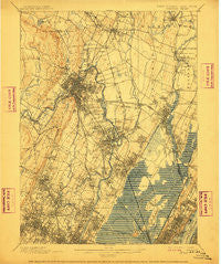
~ Paterson NJ topo map, 1:62500 scale, 15 X 15 Minute, Historical, 1903, updated 1911
Paterson, New Jersey, USGS topographic map dated 1903.
Includes geographic coordinates (latitude and longitude). This topographic map is suitable for hiking, camping, and exploring, or framing it as a wall map.
Printed on-demand using high resolution imagery, on heavy weight and acid free paper, or alternatively on a variety of synthetic materials.
Topos available on paper, Waterproof, Poly, or Tyvek. Usually shipping rolled, unless combined with other folded maps in one order.
- Product Number: USGS-5377430
- Free digital map download (high-resolution, GeoPDF): Paterson, New Jersey (file size: 10 MB)
- Map Size: please refer to the dimensions of the GeoPDF map above
- Weight (paper map): ca. 55 grams
- Map Type: POD USGS Topographic Map
- Map Series: HTMC
- Map Verison: Historical
- Cell ID: 60802
- Scan ID: 255307
- Imprint Year: 1911
- Survey Year: 1897
- Datum: Unstated
- Map Projection: Unstated
- Map published by United States Geological Survey
- Map Language: English
- Scanner Resolution: 600 dpi
- Map Cell Name: Paterson
- Grid size: 15 X 15 Minute
- Date on map: 1903
- Map Scale: 1:62500
- Geographical region: New Jersey, United States
Neighboring Maps:
All neighboring USGS topo maps are available for sale online at a variety of scales.
Spatial coverage:
Topo map Paterson, New Jersey, covers the geographical area associated the following places:
- Passaic Junction - Ampere - Belleville - Hackensack - Undercliff Junction - The Village at Little Falls - Wortendyke - Ridgefield Park - Garfield - Athenia - Orange - North Bergen - East Orange - South Hackensack - Lyndhurst - Union City - Delawanna - Hudson Heights - Albion Place - Elmwood Park - West Englewood - Montclair Heights - Hawthorne - Fair Lawn - Saddle Brook - Great Notch - Glen Rock - Riverside Terrace - River Vale - Clifton - Ho-Ho-Kus - Brookdale - North Arlington - Metropolitan Mobile Home Park - Hasbrouck Heights - Preakness - Costa Mobile Home Park - Lodi - Bloomfield - New Bridge - Montclair - Prospect Park - New Durham - Emerson - Wood-Ridge - Midland Park - Cedar Grove - Paramus - Cherry Hill - Llewellyn Park - Paterson - Rutherford - Haledon - North Haledon - Teterboro - Wallington - Vanguard Mobile Home Park - Elm Park Village - Morsemere - Ridgewood Junction - Lake View - Richfield - Ridgewood - Guttenberg - Meadow Village - Little Ferry - Arlington - River Edge - Verona - East Rutherford - Teaneck - Carlton Hill - West View - Westwood - Glen Ridge - Totowa - Allwood - Riverside - Oradell - Rochelle Park - Moonachie - Warren Point - Kearny - Singac - Maywood - Upper Montclair - Nutley - Little Falls - Avondale - Weehawken - Passaic - Woodland Park - North Hackensack - Bogota - New Milford - Babbitt - Carlstadt - Secaucus - West New York - West Orange
- Map Area ID: AREA4140.75-74.25-74
- Northwest corner Lat/Long code: USGSNW41-74.25
- Northeast corner Lat/Long code: USGSNE41-74
- Southwest corner Lat/Long code: USGSSW40.75-74.25
- Southeast corner Lat/Long code: USGSSE40.75-74
- Northern map edge Latitude: 41
- Southern map edge Latitude: 40.75
- Western map edge Longitude: -74.25
- Eastern map edge Longitude: -74


