
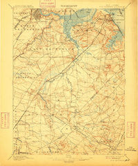
~ New Brunswick NJ topo map, 1:62500 scale, 15 X 15 Minute, Historical, 1901, updated 1909
New Brunswick, New Jersey, USGS topographic map dated 1901.
Includes geographic coordinates (latitude and longitude). This topographic map is suitable for hiking, camping, and exploring, or framing it as a wall map.
Printed on-demand using high resolution imagery, on heavy weight and acid free paper, or alternatively on a variety of synthetic materials.
Topos available on paper, Waterproof, Poly, or Tyvek. Usually shipping rolled, unless combined with other folded maps in one order.
- Product Number: USGS-5377410
- Free digital map download (high-resolution, GeoPDF): New Brunswick, New Jersey (file size: 8 MB)
- Map Size: please refer to the dimensions of the GeoPDF map above
- Weight (paper map): ca. 55 grams
- Map Type: POD USGS Topographic Map
- Map Series: HTMC
- Map Verison: Historical
- Cell ID: 58349
- Scan ID: 255295
- Imprint Year: 1909
- Survey Year: 1885
- Datum: Unstated
- Map Projection: Unstated
- Map published by United States Geological Survey
- Map Language: English
- Scanner Resolution: 600 dpi
- Map Cell Name: New Brunswick
- Grid size: 15 X 15 Minute
- Date on map: 1901
- Map Scale: 1:62500
- Geographical region: New Jersey, United States
Neighboring Maps:
All neighboring USGS topo maps are available for sale online at a variety of scales.
Spatial coverage:
Topo map New Brunswick, New Jersey, covers the geographical area associated the following places:
- Parlin - Cottageville - Helmetta - Greensand - Rutgers - Paulas Corners - Herberts - Spotswood - Jamesburg Gardens - East Freehold - Clearbrook - Texas - Brownville - Matchaponix - Spotswood Manor - Cottrell Corners - Middlesex Downs - Union Valley - Freehold - South River - Newton Heights - Thomas J Dohany Homes - Hoffman - Herberts Corner - Westons Mills - Bergen Mills - Ernston - Lafayette Mills - Gordons Corner - Morgan - Clarks Mills - Patricks Corners - South Old Bridge - Mechanicsville - Orchard Heights - Clearbrook Park - Mounts Mills - Somerset - Milltown - Redshaw Corner - Adams - Browntown - Gravel Hill - East Spotswood - Millhurst - Rossmoor - Feaster Park - Cheesequake - Crossmans - Jamesburg Park - Yorketown - Henningers Mill - Piscataway - Moerls Corner - Washington Heights - Fairview Knolls - Maple Meade - Berdines Corners - Tennent - Phoenix - Edgebrook - Robertsville - Sayre Woods - Raritan Gardens - Madison Park - Englishtown - Prospect Plains - Martins Landing - Jamesburg - Brookview - Fresh Ponds - Dunhams Corners - South Amboy - Lincoln Park - Wyckoffs Mills - Manalapan - Applegarth - Farrington Lake Heights - Monmouth Heights at Manalapan - Runyon - Old Bridge - MacArthur Manor - Highland Park - Cranbury Station - Gillespie - Morgan Heights - Sayreville Junction - Spring Valley - Taylors Mills - Melrose - East Brunswick - Twin Rivers - Laurel Park - Sayerwood South - Tanners Corners - Shore Road Estates - Lawrence Brook Manor - Brunswick Gardens - Gillilandtown - Tracy
- Map Area ID: AREA40.540.25-74.5-74.25
- Northwest corner Lat/Long code: USGSNW40.5-74.5
- Northeast corner Lat/Long code: USGSNE40.5-74.25
- Southwest corner Lat/Long code: USGSSW40.25-74.5
- Southeast corner Lat/Long code: USGSSE40.25-74.25
- Northern map edge Latitude: 40.5
- Southern map edge Latitude: 40.25
- Western map edge Longitude: -74.5
- Eastern map edge Longitude: -74.25


