
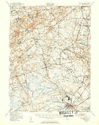
~ Lakehurst NJ topo map, 1:62500 scale, 15 X 15 Minute, Historical, 1948, updated 1954
Lakehurst, New Jersey, USGS topographic map dated 1948.
Includes geographic coordinates (latitude and longitude). This topographic map is suitable for hiking, camping, and exploring, or framing it as a wall map.
Printed on-demand using high resolution imagery, on heavy weight and acid free paper, or alternatively on a variety of synthetic materials.
Topos available on paper, Waterproof, Poly, or Tyvek. Usually shipping rolled, unless combined with other folded maps in one order.
- Product Number: USGS-5377294
- Free digital map download (high-resolution, GeoPDF): Lakehurst, New Jersey (file size: 10 MB)
- Map Size: please refer to the dimensions of the GeoPDF map above
- Weight (paper map): ca. 55 grams
- Map Type: POD USGS Topographic Map
- Map Series: HTMC
- Map Verison: Historical
- Cell ID: 56505
- Scan ID: 255235
- Imprint Year: 1954
- Aerial Photo Year: 1947
- Field Check Year: 1948
- Datum: NAD27
- Map Projection: Polyconic
- Map published by United States Geological Survey
- Map published by United States Army Corps of Engineers
- Map Language: English
- Scanner Resolution: 600 dpi
- Map Cell Name: Lakehurst
- Grid size: 15 X 15 Minute
- Date on map: 1948
- Map Scale: 1:62500
- Geographical region: New Jersey, United States
Neighboring Maps:
All neighboring USGS topo maps are available for sale online at a variety of scales.
Spatial coverage:
Topo map Lakehurst, New Jersey, covers the geographical area associated the following places:
- Bennetts Mills - Matthews - Holmansville - Francis Mills - Siloam - Perrineville - Edgewood Park - Stonehurst East - Ely - Legler - Southwind Mobile Home Park - Archertown - Elton - West Freehold - Oakland Mills - Stone Tavern - Adelphia - Fair Play - Hyson - Cedar Glen West - Holmeson - Maryland - Pleasant Grove - Elys Corner - Clarksburg - Archers Corner - Charleston Springs - Oakwood - Emleys Hill - Van Hiseville - Carrs Tavern - Red Valley - Prospertown - Jacksons Mills - Woodmere - Cassville - Midwood - Wyckoff Mills - Leisure Knoll - Georgia - Robinsville - Roosevelt - Sweetman - Leisure Village West - Lakehurst - Colliers Mills - Bergerville - Bairdsville - Pine Lake Park - Woodair Estates - Saint Vladimirs - Ridgeway - Leesville - Whitesville - Fort Plains - Carrs Corner - Smithburg - Vista Center - Woodruff - Stonehurst West - Harmony - Burkesville
- Map Area ID: AREA40.2540-74.5-74.25
- Northwest corner Lat/Long code: USGSNW40.25-74.5
- Northeast corner Lat/Long code: USGSNE40.25-74.25
- Southwest corner Lat/Long code: USGSSW40-74.5
- Southeast corner Lat/Long code: USGSSE40-74.25
- Northern map edge Latitude: 40.25
- Southern map edge Latitude: 40
- Western map edge Longitude: -74.5
- Eastern map edge Longitude: -74.25


