
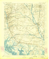
~ Bridgeton NJ topo map, 1:62500 scale, 15 X 15 Minute, Historical, 1894, updated 1924
Bridgeton, New Jersey, USGS topographic map dated 1894.
Includes geographic coordinates (latitude and longitude). This topographic map is suitable for hiking, camping, and exploring, or framing it as a wall map.
Printed on-demand using high resolution imagery, on heavy weight and acid free paper, or alternatively on a variety of synthetic materials.
Topos available on paper, Waterproof, Poly, or Tyvek. Usually shipping rolled, unless combined with other folded maps in one order.
- Product Number: USGS-5377124
- Free digital map download (high-resolution, GeoPDF): Bridgeton, New Jersey (file size: 8 MB)
- Map Size: please refer to the dimensions of the GeoPDF map above
- Weight (paper map): ca. 55 grams
- Map Type: POD USGS Topographic Map
- Map Series: HTMC
- Map Verison: Historical
- Cell ID: 51771
- Scan ID: 255140
- Imprint Year: 1924
- Survey Year: 1886
- Datum: NAD
- Map Projection: Polyconic
- Map published by United States Geological Survey
- Map Language: English
- Scanner Resolution: 600 dpi
- Map Cell Name: Bridgeton
- Grid size: 15 X 15 Minute
- Date on map: 1894
- Map Scale: 1:62500
- Geographical region: New Jersey, United States
Neighboring Maps:
All neighboring USGS topo maps are available for sale online at a variety of scales.
Spatial coverage:
Topo map Bridgeton, New Jersey, covers the geographical area associated the following places:
- Carlls Corner - Dividing Creek - Finley - Fairton - New Italy - Millville - Lummistown - Newport - Shaws Mill - Carmel - Laurel Lake - Clayville - Tindells Landing - Bridgeton Junction - Haleyville - Paynters Crossing - Rammel Mill - Watsons Corner - Newport Landing - Gandys Beach - Centre Grove - Turkey Point Corner - New England Crossroads - Frames Corner - Big Oak - South Vineland - Woodruff - Baileytown - Gouldtown - Fordville - Vineland - Roosevelt Park - Garton - Rosenhayn - Bridgeton - Orchard Center - Necombtown - Clarks Mill - Cedarville - Lores Mill - Friendship - Norma - Dragston - North Port Norris - Farmingdale - Buckshutem
- Map Area ID: AREA39.539.25-75.25-75
- Northwest corner Lat/Long code: USGSNW39.5-75.25
- Northeast corner Lat/Long code: USGSNE39.5-75
- Southwest corner Lat/Long code: USGSSW39.25-75.25
- Southeast corner Lat/Long code: USGSSE39.25-75
- Northern map edge Latitude: 39.5
- Southern map edge Latitude: 39.25
- Western map edge Longitude: -75.25
- Eastern map edge Longitude: -75


