
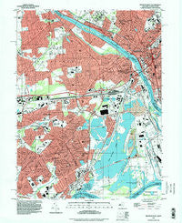
~ Trenton West NJ topo map, 1:24000 scale, 7.5 X 7.5 Minute, Historical, 1995, updated 1998
Trenton West, New Jersey, USGS topographic map dated 1995.
Includes geographic coordinates (latitude and longitude). This topographic map is suitable for hiking, camping, and exploring, or framing it as a wall map.
Printed on-demand using high resolution imagery, on heavy weight and acid free paper, or alternatively on a variety of synthetic materials.
Topos available on paper, Waterproof, Poly, or Tyvek. Usually shipping rolled, unless combined with other folded maps in one order.
- Product Number: USGS-5376812
- Free digital map download (high-resolution, GeoPDF): Trenton West, New Jersey (file size: 19 MB)
- Map Size: please refer to the dimensions of the GeoPDF map above
- Weight (paper map): ca. 55 grams
- Map Type: POD USGS Topographic Map
- Map Series: HTMC
- Map Verison: Historical
- Cell ID: 45630
- Scan ID: 254935
- Imprint Year: 1998
- Woodland Tint: Yes
- Aerial Photo Year: 1995
- Datum: NAD83
- Map Projection: Universal Transverse Mercator
- Map published by United States Geological Survey
- Map Language: English
- Scanner Resolution: 600 dpi
- Map Cell Name: Trenton West
- Grid size: 7.5 X 7.5 Minute
- Date on map: 1995
- Map Scale: 1:24000
- Geographical region: New Jersey, United States
Neighboring Maps:
All neighboring USGS topo maps are available for sale online at a variety of scales.
Spatial coverage:
Topo map Trenton West, New Jersey, covers the geographical area associated the following places:
- Quincy Hollow - Yardley - Edge Hill - Vermilion Hill - North Park - Roelofs - Magnolia Hill - Tullytown - Penn Valley - Mill Creek Falls - Levittown - Birch Valley - Farmbrook - Appletree Hill - Five Points - Blue Ridge - Wheat Sheaf - Dunlap - Indian Creek - Weber Park - Holly Hill - Edgely - Prospect Park - Emilie - Scammells Corner - Oxford Valley - Will O Wood - Wood - Goldenridge - Red Cedar Hill - Pinewood - Upper Emilie - Morrisville - Fairless Hills - Fallsington - Yellowood - Lakeside - Dogwood Hollow - Violet Wood - Elderberry Pond - Oaktree Hollow - Hillcrest - Greenbrook - Cobalt Ridge - Prospect Heights - Stonybrook - Glendale - Thornridge - Whitewood - Crabtree Hollow
- Map Area ID: AREA40.2540.125-74.875-74.75
- Northwest corner Lat/Long code: USGSNW40.25-74.875
- Northeast corner Lat/Long code: USGSNE40.25-74.75
- Southwest corner Lat/Long code: USGSSW40.125-74.875
- Southeast corner Lat/Long code: USGSSE40.125-74.75
- Northern map edge Latitude: 40.25
- Southern map edge Latitude: 40.125
- Western map edge Longitude: -74.875
- Eastern map edge Longitude: -74.75


