
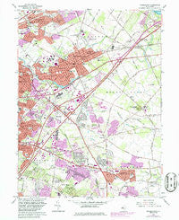
~ Moorestown NJ topo map, 1:24000 scale, 7.5 X 7.5 Minute, Historical, 1966, updated 1986
Moorestown, New Jersey, USGS topographic map dated 1966.
Includes geographic coordinates (latitude and longitude). This topographic map is suitable for hiking, camping, and exploring, or framing it as a wall map.
Printed on-demand using high resolution imagery, on heavy weight and acid free paper, or alternatively on a variety of synthetic materials.
Topos available on paper, Waterproof, Poly, or Tyvek. Usually shipping rolled, unless combined with other folded maps in one order.
- Product Number: USGS-5376234
- Free digital map download (high-resolution, GeoPDF): Moorestown, New Jersey (file size: 14 MB)
- Map Size: please refer to the dimensions of the GeoPDF map above
- Weight (paper map): ca. 55 grams
- Map Type: POD USGS Topographic Map
- Map Series: HTMC
- Map Verison: Historical
- Cell ID: 30125
- Scan ID: 254595
- Imprint Year: 1986
- Woodland Tint: Yes
- Photo Revision Year: 1981
- Aerial Photo Year: 1975
- Edit Year: 1981
- Survey Year: 1953
- Datum: NAD27
- Map Projection: Polyconic
- Map published by United States Geological Survey
- Map Language: English
- Scanner Resolution: 600 dpi
- Map Cell Name: Moorestown
- Grid size: 7.5 X 7.5 Minute
- Date on map: 1966
- Map Scale: 1:24000
- Geographical region: New Jersey, United States
Neighboring Maps:
All neighboring USGS topo maps are available for sale online at a variety of scales.
Spatial coverage:
Topo map Moorestown, New Jersey, covers the geographical area associated the following places:
- Hartford - Greentree Village - Greenhaven - Marlton - Birchfield - Kingston Estates - Fox Hollow Woods - Pine Grove - Ramblewood - Wexford East - Donlontown - Northwood - Wellington Park - Cambridge - Barclay Farm - Deer Park - Springdale - Marlboro - Stanwick - Stow Acres - Woodstream - Point of Woods - Moorestown - Surrey Place - Greentree - Cherry Downs - Colestown - Fellowship - Wrightsville - Maple Shade - Coxs Corner - Cinnaminson - Lenola - Cropwell - Ivywood - Deerwoods - Evans Corner - Pheasant Run - Heritage Village - Texas - Colemantown - Candlewyck - Willowdale - Cherry Valley - Bougher - Mount Laurel - Stanwick Glen - The Maples - Charleston East - Locust Grove - Evesboro - West Moorestown
- Map Area ID: AREA4039.875-75-74.875
- Northwest corner Lat/Long code: USGSNW40-75
- Northeast corner Lat/Long code: USGSNE40-74.875
- Southwest corner Lat/Long code: USGSSW39.875-75
- Southeast corner Lat/Long code: USGSSE39.875-74.875
- Northern map edge Latitude: 40
- Southern map edge Latitude: 39.875
- Western map edge Longitude: -75
- Eastern map edge Longitude: -74.875


