
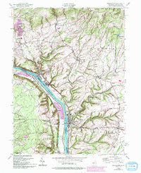
~ Frenchtown NJ topo map, 1:24000 scale, 7.5 X 7.5 Minute, Historical, 1955, updated 1994
Frenchtown, New Jersey, USGS topographic map dated 1955.
Includes geographic coordinates (latitude and longitude). This topographic map is suitable for hiking, camping, and exploring, or framing it as a wall map.
Printed on-demand using high resolution imagery, on heavy weight and acid free paper, or alternatively on a variety of synthetic materials.
Topos available on paper, Waterproof, Poly, or Tyvek. Usually shipping rolled, unless combined with other folded maps in one order.
- Product Number: USGS-5375940
- Free digital map download (high-resolution, GeoPDF): Frenchtown, New Jersey (file size: 14 MB)
- Map Size: please refer to the dimensions of the GeoPDF map above
- Weight (paper map): ca. 55 grams
- Map Type: POD USGS Topographic Map
- Map Series: HTMC
- Map Verison: Historical
- Cell ID: 16442
- Scan ID: 254416
- Imprint Year: 1994
- Woodland Tint: Yes
- Photo Revision Year: 1994
- Aerial Photo Year: 1991
- Edit Year: 1994
- Datum: NAD27
- Map Projection: Transverse Mercator
- Map published by United States Army Corps of Engineers
- Map Language: English
- Scanner Resolution: 600 dpi
- Map Cell Name: Frenchtown
- Grid size: 7.5 X 7.5 Minute
- Date on map: 1955
- Map Scale: 1:24000
- Geographical region: New Jersey, United States
Neighboring Maps:
All neighboring USGS topo maps are available for sale online at a variety of scales.
Spatial coverage:
Topo map Frenchtown, New Jersey, covers the geographical area associated the following places:
- Everbreeze Plateau - Everittstown - Baptistown - Lodi - Spring Mills - Little York - Uhlerstown - Jugtown - Palmyra - Ruppletown - Milford - Mount Pleasant - Erwinna - Clay Ridge - Chestnut Ridge Acres - Upper Black Eddy - Riegel Ridge - Frenchtown - Golden Acres Estates
- Map Area ID: AREA40.62540.5-75.125-75
- Northwest corner Lat/Long code: USGSNW40.625-75.125
- Northeast corner Lat/Long code: USGSNE40.625-75
- Southwest corner Lat/Long code: USGSSW40.5-75.125
- Southeast corner Lat/Long code: USGSSE40.5-75
- Northern map edge Latitude: 40.625
- Southern map edge Latitude: 40.5
- Western map edge Longitude: -75.125
- Eastern map edge Longitude: -75


