
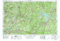
~ Greensboro NC topo map, 1:250000 scale, 1 X 2 Degree, Historical, 1953, updated 1981
Greensboro, North Carolina, USGS topographic map dated 1953.
Includes geographic coordinates (latitude and longitude). This topographic map is suitable for hiking, camping, and exploring, or framing it as a wall map.
Printed on-demand using high resolution imagery, on heavy weight and acid free paper, or alternatively on a variety of synthetic materials.
Topos available on paper, Waterproof, Poly, or Tyvek. Usually shipping rolled, unless combined with other folded maps in one order.
- Product Number: USGS-5375022
- Free digital map download (high-resolution, GeoPDF): Greensboro, North Carolina (file size: 24 MB)
- Map Size: please refer to the dimensions of the GeoPDF map above
- Weight (paper map): ca. 55 grams
- Map Type: POD USGS Topographic Map
- Map Series: HTMC
- Map Verison: Historical
- Cell ID: 68807
- Scan ID: 162534
- Imprint Year: 1981
- Woodland Tint: Yes
- Photo Revision Year: 1980
- Aerial Photo Year: 1978
- Edit Year: 1980
- Field Check Year: 1953
- Datum: NAD27
- Map Projection: Transverse Mercator
- Map published by United States Geological Survey
- Map Language: English
- Scanner Resolution: 600 dpi
- Map Cell Name: Greensboro
- Grid size: 1 X 2 Degree
- Date on map: 1953
- Map Scale: 1:250000
- Geographical region: North Carolina, United States
Neighboring Maps:
All neighboring USGS topo maps are available for sale online at a variety of scales.
Spatial coverage:
Topo map Greensboro, North Carolina, covers the geographical area associated the following places:
- Grove Park - Denniston - Whitmell - Gill - Purnell - Turbeville - Cunningham - Gretna - Marmaduke - Friendly Homes - Fairfield Park - Seven Mills Farms - Starlings Crossroads - Hillcrest - Stephens Crossroads - Gold Hill - Green Tree - Norwood - Semora - Brookston - Chatham - Larry Hall - Scott Park - Hunter Hills - Baskerville - Culbreth - Berryland - Hamer - Terra Cotta - Oakhaven Farms - Creekridge - Cornwallis Hills - Hunting Hills - Redlawn - Sandy Ridge - Leaksville Junction - Transco Village - Dan Valley - Tar River - Gela - Cedar Grove - Sandy Fork - Just Crossroads - Sunset Ridge - Fairfield - Clarksville - Lakeview Acres - Canaan Park - Church Hill - Lancaster Crossroads - Woodshire Estates - Kings Crossroads - Country Place - Covington - Halloway (historical) - Loftis - Hinesville - Rogers Corner - Dexter - Mountain Road - Overland Heights - Rockwood Acres - Pleasant Grove - The Pines - Grand Oaks - Whispering Pines - Martindale Acres - Wedgewood West - East White Oak - Cal-Vel - Whitsett - Pelham - Gorman - Nathalie - Weal - Greesons Crossroads - Sonans - Kearney - Gupton - Rankin - Lawsonville - Alamance Acres - Adams Farm - Hamilton Lakes - Spring Garden - Trentwood - Dundee - Glenwood - Brigadoon - Farmers - Brentwood Park - Sunset Hills - Sherwood Forest - Wolf Trap - Gills - Stones Mill - Elkhorn - Guerrant Springs (historical) - Pullens - Oak Level
- Map Area ID: AREA3736-80-78
- Northwest corner Lat/Long code: USGSNW37-80
- Northeast corner Lat/Long code: USGSNE37-78
- Southwest corner Lat/Long code: USGSSW36-80
- Southeast corner Lat/Long code: USGSSE36-78
- Northern map edge Latitude: 37
- Southern map edge Latitude: 36
- Western map edge Longitude: -80
- Eastern map edge Longitude: -78


