
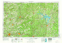
~ Greensboro NC topo map, 1:250000 scale, 1 X 2 Degree, Historical, 1966
Greensboro, North Carolina, USGS topographic map dated 1966.
Includes geographic coordinates (latitude and longitude). This topographic map is suitable for hiking, camping, and exploring, or framing it as a wall map.
Printed on-demand using high resolution imagery, on heavy weight and acid free paper, or alternatively on a variety of synthetic materials.
Topos available on paper, Waterproof, Poly, or Tyvek. Usually shipping rolled, unless combined with other folded maps in one order.
- Product Number: USGS-5375020
- Free digital map download (high-resolution, GeoPDF): Greensboro, North Carolina (file size: 22 MB)
- Map Size: please refer to the dimensions of the GeoPDF map above
- Weight (paper map): ca. 55 grams
- Map Type: POD USGS Topographic Map
- Map Series: HTMC
- Map Verison: Historical
- Cell ID: 68807
- Scan ID: 162531
- Woodland Tint: Yes
- Edit Year: 1962
- Field Check Year: 1953
- Datum: Unstated
- Map Projection: Transverse Mercator
- Map published by United States Geological Survey
- Map Language: English
- Scanner Resolution: 600 dpi
- Map Cell Name: Greensboro
- Grid size: 1 X 2 Degree
- Date on map: 1966
- Map Scale: 1:250000
- Geographical region: North Carolina, United States
Neighboring Maps:
All neighboring USGS topo maps are available for sale online at a variety of scales.
Spatial coverage:
Topo map Greensboro, North Carolina, covers the geographical area associated the following places:
- Leda - Beverstone Park - Hurdle Mills - Casville - Danville Estates - Gilmer Terrace - Pennydale - Sandy Plain - Vandalia - Woodshire Estates - Beverly Heights - Davis Store - Gills - Willow Oaks - Fairview - Omega - Cozart - Westridge Heights - Bakers Crossroads - Laurel Bluffs - Southmont - Jackson Park - Clarkton - Sheffield Terrace - Surl - Fisher Park - Hickory Rock - Wightman - Axton - Fordland Estates - Haw River - Latham Town - Sugar Ridge - Reywin Acres - Dan River (historical) - Gills Corner - Glen Court - Newton (historical) - Piedmont Heights - Ossipee - Rock Run - Whits Point - Lake View - Shannon Park - Blanks - Tungsten - Bagleys Mills - Opie - Lynnbrook Estates - Keats - Ashland - South Boston - Maple Grove Acres - Katesville - Starmount Forest - Clover Garden - Hopewell - Chestnut Knob - Eastwood - White Oak - Virgilina - Timberlake - Collinsville - Summerfield - Rankin - Mount Cross - Stagecoach Forest - Clays Mill - University Acres - Paces - Bosses - McCray - Cedar Hill - Popes Crossroads - Stallings Crossroads - Ebenezer - McGehees Mill - Adcock Crossroads - Johnson Corner - Presbyterian Point - Smith Acres - Red Bank - Hagood - Deerfield - Cheeks Crossroads - Stokesland - Birch - Piney Grove - Holly Meadows - Ogburn - Lakeview Acres - Church Hill - Mayo - Oak Hills - Lakewood - Museville - Green Pines - Mount Airy - Greenhaven - Ai
- Map Area ID: AREA3736-80-78
- Northwest corner Lat/Long code: USGSNW37-80
- Northeast corner Lat/Long code: USGSNE37-78
- Southwest corner Lat/Long code: USGSSW36-80
- Southeast corner Lat/Long code: USGSSE36-78
- Northern map edge Latitude: 37
- Southern map edge Latitude: 36
- Western map edge Longitude: -80
- Eastern map edge Longitude: -78


