
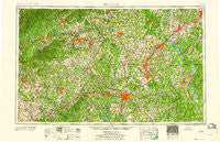
~ Charlotte NC topo map, 1:250000 scale, 1 X 2 Degree, Historical, 1960
Charlotte, North Carolina, USGS topographic map dated 1960.
Includes geographic coordinates (latitude and longitude). This topographic map is suitable for hiking, camping, and exploring, or framing it as a wall map.
Printed on-demand using high resolution imagery, on heavy weight and acid free paper, or alternatively on a variety of synthetic materials.
Topos available on paper, Waterproof, Poly, or Tyvek. Usually shipping rolled, unless combined with other folded maps in one order.
- Product Number: USGS-5375006
- Free digital map download (high-resolution, GeoPDF): Charlotte, North Carolina (file size: 25 MB)
- Map Size: please refer to the dimensions of the GeoPDF map above
- Weight (paper map): ca. 55 grams
- Map Type: POD USGS Topographic Map
- Map Series: HTMC
- Map Verison: Historical
- Cell ID: 68711
- Scan ID: 164183
- Woodland Tint: Yes
- Field Check Year: 1953
- Datum: Unstated
- Map Projection: Transverse Mercator
- Map published by United States Geological Survey
- Map Language: English
- Scanner Resolution: 600 dpi
- Map Cell Name: Charlotte
- Grid size: 1 X 2 Degree
- Date on map: 1960
- Map Scale: 1:250000
- Geographical region: North Carolina, United States
Neighboring Maps:
All neighboring USGS topo maps are available for sale online at a variety of scales.
Spatial coverage:
Topo map Charlotte, North Carolina, covers the geographical area associated the following places:
- Hickory Hills - Allison Ferry - North Kannapolis - Millerton (historical) - Rutledge Acres - Spring Valley - Morning Star Acres - Bryans Woods - Garfield (historical) - Danbury Forest - Healing Springs - Midway - Tyro - Freewood Acres - Maud - Parkstone - East Monbo - Hibriten (historical) - Meadowbrook Estates - Cajahs Mountain - Mount Gilead - Webbs - Rain Forest - Fox Run - Sunnyside - Southmont - Weatherstone - Colony Acres - Sherwood Forest - Knollwood Acres - Old Orchid - Idlewild Terrace Apartments - Coulwood Hills - Georgeville - Knob Creek - Hillcrest - Dogwood Springs Park - Gatewood - Laurelwood - Cabarrus - Pinecrest - Tanglewood - Midway - Windsong Trails - Bloomfield - Riverview - Catawba Heights - Quail Hollow - Lincoln Estates - Drys Mill (historical) - Statesville - Cold Springs - Monbo - Lock (historical) - Dallas - Clubview Acres - Enochville - Brummels (historical) - Shanghai - Northlakes - Fair Grove - Mason Estates - Kimberly Courts - Weddington - Maple Valley - Farmwood - Pinkston - Raintree - Sedgefield Acres - Orchard Knoll - Heathergate - Lexington - Jersey - Ellenboro - Hulls Crossroads - Wellington Woods - Palestine - Arrowwood - Olive Grove - Heidleberg Settlement - Indian Hills - Ridgewood Acres - Southminister Woods - Montclaire South - Green Acres - Byersville (historical) - Brooklyn - Hampton Park - Lake Wylie - Fulton Heights - Light - Moyle Heights - Montclair - Cotswold - Western Heights - Cansellers - Pumpkin Center - Morganton - Southside - Crowders (historical)
- Map Area ID: AREA3635-82-80
- Northwest corner Lat/Long code: USGSNW36-82
- Northeast corner Lat/Long code: USGSNE36-80
- Southwest corner Lat/Long code: USGSSW35-82
- Southeast corner Lat/Long code: USGSSE35-80
- Northern map edge Latitude: 36
- Southern map edge Latitude: 35
- Western map edge Longitude: -82
- Eastern map edge Longitude: -80


