
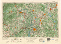
~ Charlotte NC topo map, 1:250000 scale, 1 X 2 Degree, Historical, 1954
Charlotte, North Carolina, USGS topographic map dated 1954.
Includes geographic coordinates (latitude and longitude). This topographic map is suitable for hiking, camping, and exploring, or framing it as a wall map.
Printed on-demand using high resolution imagery, on heavy weight and acid free paper, or alternatively on a variety of synthetic materials.
Topos available on paper, Waterproof, Poly, or Tyvek. Usually shipping rolled, unless combined with other folded maps in one order.
- Product Number: USGS-5375004
- Free digital map download (high-resolution, GeoPDF): Charlotte, North Carolina (file size: 28 MB)
- Map Size: please refer to the dimensions of the GeoPDF map above
- Weight (paper map): ca. 55 grams
- Map Type: POD USGS Topographic Map
- Map Series: HTMC
- Map Verison: Historical
- Cell ID: 68711
- Scan ID: 164182
- Woodland Tint: Yes
- Field Check Year: 1953
- Datum: Unstated
- Map Projection: Transverse Mercator
- Map published by United States Geological Survey
- Map published by United States Army Corps of Engineers
- Map Language: English
- Scanner Resolution: 600 dpi
- Map Cell Name: Charlotte
- Grid size: 1 X 2 Degree
- Date on map: 1954
- Map Scale: 1:250000
- Geographical region: North Carolina, United States
Neighboring Maps:
All neighboring USGS topo maps are available for sale online at a variety of scales.
Spatial coverage:
Topo map Charlotte, North Carolina, covers the geographical area associated the following places:
- Shinnville - Twins Estates - Mocksville - Startown - Camp Cox - Cid - Darby Acres - Cornatzer - Westbourne - Pinkston - Stanley - Midway - Briarwood Acres - Smithville - Polkton - Tryon - Rehobeth - Liledoun - Pineburr - Sardis (historical) - Loray - Cloaninger - Pine Mountain Lakes - Wood Hollow - Severville - Fernwood - Golden (historical) - Cold Water - Twin Creek - Fairgrove - Fullerdale - Windsor Park - Hardaway (historical) - Westwood - Eastfield (historical) - China Grove - Brittain Village - Bellwood - Northgate - Table Rock - Hatterbrond (historical) - Deerhurst - Torrance (historical) - Hildebran - Grove Park - Denver - Hidden Valley - Cold Springs - Kinghurst Park - Reynolds Mobile Home Park - Carlisle - Sharp (historical) - Tremont Park - Homestead Acres - Mount Mitchell - Allison Ferry - Crater Park - Lockewood - Martins Store - Barber - Jefferson Heights - Centerview - Blackburn - Currytown - Ourdell - Sandy Ridge Terrace - Walks (historical) - Pine Ridge - Mountain View - Walser - Hiddenite - Sardis Oaks - Forest Lake Homes - Springhaven - Westwood - Adako - Sunnyside - Rhodhiss - Hickory - Meadow Brook Village - Shoally Creek - Spencer Heights - Crestmont - New Salem - Gidney Homes - Eaman Park - Sharon Apartments - Bishops Ridge - Millerton (historical) - Kawana - Springdale Estates - Firestone - Baton - Turnersburg - Pinedell - Tega Cay - Duan - Light Oak - Jersey - Farmland Acres
- Map Area ID: AREA3635-82-80
- Northwest corner Lat/Long code: USGSNW36-82
- Northeast corner Lat/Long code: USGSNE36-80
- Southwest corner Lat/Long code: USGSSW35-82
- Southeast corner Lat/Long code: USGSSE35-80
- Northern map edge Latitude: 36
- Southern map edge Latitude: 35
- Western map edge Longitude: -82
- Eastern map edge Longitude: -80


