
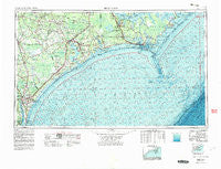
~ Beaufort NC topo map, 1:250000 scale, 1 X 2 Degree, Historical, 1953, updated 1983
Beaufort, North Carolina, USGS topographic map dated 1953.
Includes geographic coordinates (latitude and longitude). This topographic map is suitable for hiking, camping, and exploring, or framing it as a wall map.
Printed on-demand using high resolution imagery, on heavy weight and acid free paper, or alternatively on a variety of synthetic materials.
Topos available on paper, Waterproof, Poly, or Tyvek. Usually shipping rolled, unless combined with other folded maps in one order.
- Product Number: USGS-5375002
- Free digital map download (high-resolution, GeoPDF): Beaufort, North Carolina (file size: 24 MB)
- Map Size: please refer to the dimensions of the GeoPDF map above
- Weight (paper map): ca. 55 grams
- Map Type: POD USGS Topographic Map
- Map Series: HTMC
- Map Verison: Historical
- Cell ID: 68666
- Scan ID: 163716
- Imprint Year: 1983
- Woodland Tint: Yes
- Edit Year: 1972
- Field Check Year: 1953
- Datum: NAD27
- Map Projection: Transverse Mercator
- Map published by United States Geological Survey
- Map Language: English
- Scanner Resolution: 600 dpi
- Map Cell Name: Beaufort
- Grid size: 1 X 2 Degree
- Date on map: 1953
- Map Scale: 1:250000
- Geographical region: North Carolina, United States
Neighboring Maps:
All neighboring USGS topo maps are available for sale online at a variety of scales.
Spatial coverage:
Topo map Beaufort, North Carolina, covers the geographical area associated the following places:
- Seagate - Walkers Store - Carrol C Mobile Home Park - Six Forks - The Pines Mobile Home Park - Paradise Bay Mobile Home Park - Blades - Masontown - Cypress Creek - Lauradale - Walnut Creek - Holiday City Mobile Home Park - Humphrey - Pala Alto - Atlantic Beach - Little Port - Lenoxville - Ogden - Beulaville - Straits - Alandale - Harkers Island - Richlands - Willard - Dixon - Docs Mobile Home Park - Momford Landing - Skippers Corner - Wildwood Mobile Home Park - Wilmington Beach - Glynnwood Mobile Home Park - Westgate - Oak Grove - Lee Acres Mobile Home Park - Queens Point - Roe - Lola - Greenbriar - Richardsons Mobile Home Park - Janeiro - Lake Forest - Knox Trailer Park - Flanner Beach - Marines - Country Club Hills - Tosacal Mobile Home Park - James Mobile Home Park - Echo Farms - Havelock - Greencrest - Camelot Mobile Park - Sanderson Mobile Home Park - College Park - Great Neck - The Palms Mobile Home Park - North Woods - Saint Helena - Briar Creek Mobile Home Park - Westwood Heights - Oaksmith Acres - Keeter Park - Foxhorn Village - The Black Cat - Hidden Lakes Mobile Home Park - Port-O-Pines Estates - Cyrus - Midway Park - Cherry Point (historical) - Camp Bryan - College Park - Winter Park - Cedarville Estates - Ashley Place - Morehead City - Harlowe - Devon Park - D and H Estates Mobile Home Park - Jacksons Crossroads - Georgetown - Butler Mobile Home Community - Bradley Creek East Estates - Spooners Creek Harbor - Country Club East - Highsmith - Summersill Estates - Francktown - Pine Hill - Hallsville - Ramseys Mobile Home Park - Mooretown - Morton Fork - Hancock Village - Maready - Verona - Colonial Hills - Pine Knoll Shores - Potters Mobile Home Park - Hillcrest Mobile Home Subdivision - Murphey - Shore Acres
- Map Area ID: AREA3534-78-76
- Northwest corner Lat/Long code: USGSNW35-78
- Northeast corner Lat/Long code: USGSNE35-76
- Southwest corner Lat/Long code: USGSSW34-78
- Southeast corner Lat/Long code: USGSSE34-76
- Northern map edge Latitude: 35
- Southern map edge Latitude: 34
- Western map edge Longitude: -78
- Eastern map edge Longitude: -76


