
~ Beaufort NC topo map, 1:250000 scale, 1 X 2 Degree, Historical, 1972, updated 1975
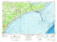
Beaufort, North Carolina, USGS topographic map dated 1972.
Includes geographic coordinates (latitude and longitude). This topographic map is suitable for hiking, camping, and exploring, or framing it as a wall map.
Printed on-demand using high resolution imagery, on heavy weight and acid free paper, or alternatively on a variety of synthetic materials.
Topos available on paper, Waterproof, Poly, or Tyvek. Usually shipping rolled, unless combined with other folded maps in one order.
- Product Number: USGS-5375000
- Free digital map download (high-resolution, GeoPDF): Beaufort, North Carolina (file size: 20 MB)
- Map Size: please refer to the dimensions of the GeoPDF map above
- Weight (paper map): ca. 55 grams
- Map Type: POD USGS Topographic Map
- Map Series: HTMC
- Map Verison: Historical
- Cell ID: 68666
- Scan ID: 163715
- Imprint Year: 1975
- Woodland Tint: Yes
- Edit Year: 1971
- Field Check Year: 1953
- Datum: Unstated
- Map Projection: Transverse Mercator
- Map published by United States Geological Survey
- Map Language: English
- Scanner Resolution: 600 dpi
- Map Cell Name: Beaufort
- Grid size: 1 X 2 Degree
- Date on map: 1972
- Map Scale: 1:250000
- Geographical region: North Carolina, United States
Neighboring Maps:
All neighboring USGS topo maps are available for sale online at a variety of scales.
Spatial coverage:
Topo map Beaufort, North Carolina, covers the geographical area associated the following places:
- Kirkland - Seagate - Channel Acres - The Black Cat - Docs Mobile Home Park - Brandywine - Camp Bryan - Sunset Park - Holly Ridge - Manteo - Brynn Marr - Petersburg - Momford Landing - Cedarville Estates - Ocean - Pine Knoll Shores - Bryan Mobile Home Park - Bucks Corner - Harmony Village Mobile Home Park - Roe - McDaniels - Lillipad Mobile Home Park - Queen Creek Mobile Home Park - Country Club Point - Dixon - Ramseys Mobile Home Park - Tarawa Terrace II - Millbrook - Berkeley Manor Area - Hadley - Falcon Point - Clairmont - Shell Bank - Francktown - Riverside Mobile Home Park - Rosemans Mobile Home Park - McArthur Estates - Six Forks - Padgett - Dunescape Condos - Treasure Cove - Wrightsboro Acres - Lola - Rocky Point - Town Ranch Heights - Ocean Crest - Briar Creek Mobile Home Park - Edgewater Estates - Steep Pines Fork - Carolina Beach - Hickory Hills West Trailer Park - Jacksons Crossroads - Slocun Village - Shaken - Hilltop Acres - Pebble Beach - Paradise Park - Shamrock Village - North Topsail Beach - Duck Creek - Murraysville - Cedar Creek - Joslyn Trace - Westgate - Echo Farms - Knox Area - Fairlawn - Coastal Shores - Greystone Estates - Mandy Farms - Swansboro - Ocean City Beach - Wildwood - Bowdens Mobile Home Park - White Stocking - Lakewood - Ponderosa Mobile Home Park - Indian Springs - Lands End - Royal Palms Mobile Home Park - Lauradale - Cherry Point Marine Base Mobile Home Park - Turtle Cove Mobile Home Park - Tar Landing - Glynnwood Mobile Home Park - Core Creek - Cabin - Park Place Mobile Home Park - Willis Landing - Stone Mobile Home Park - Cartersville - Deerfield Mobile Home Park - Grants Mobile Home Park - Oaksmith Acres - Sea Breeze - West Onslow Beach - Tarawa Terrace I - Glen Meade - Little Kelly - Silverdale
- Map Area ID: AREA3534-78-76
- Northwest corner Lat/Long code: USGSNW35-78
- Northeast corner Lat/Long code: USGSNE35-76
- Southwest corner Lat/Long code: USGSSW34-78
- Southeast corner Lat/Long code: USGSSE34-76
- Northern map edge Latitude: 35
- Southern map edge Latitude: 34
- Western map edge Longitude: -78
- Eastern map edge Longitude: -76


